|
|
|
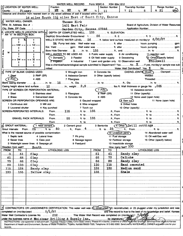
Specific Water Well Detail |
|
|
| Location Info | |||
| Owner: Kirk, Thomas | Status: Constructed | ||
| Location: T21S, R31W, Sec. 11, NE NE NW | County: Finney | ||
| Directions: from Scott City, 16 mi S, 11.5 mi E | |||
| Latitude: 38.2490458 | Longitude: -100.6933678 | Datum NAD 27 | |
| Latitude: 38.2490662 | Longitude: -100.6937961 | Datum NAD 83 | |
| Longitude and latitude calculated by Survey from township-range-section-quarter calls. Only good to within the quarter call accuracy. | |||
| View well on interactive map | |||
| General Info | ||
| Well Depth: 135 ft. | Elevation: ft. | |
| Static Water Level: 56 ft. | Est. Yield: gpm. | |
| Comp. Date: 01-Jul-1987 | Well Use: Domestic, Livestock | |
| DWR Applic. #: | Other ID: | |
| Driller Info | ||
| Driller: Weishaar Drilling & Supply, Inc. | License #: 232 | |
| Scanned Form | View scan |
|
Chemical Sample Submitted?: No
Water Well disinfected?: | ||
| Ground water encountered: 56 ft. , 0 ft. , 0 ft. | ||
| Pump test data: Well water was 0 ft after 0 hours pumping 0 gpm | ||
| Casing Info | ||
| Casing Type: PVC
Casing Joints: |
Diam: 5 in. to 15 ft
Diam: 0 in. to 0 ft Diam: 0 in. to 0 ft | |
| Casing height above land surface: in
Casing Weight: lbs/ft Wall thickness or gauge no.: | ||
| Screen and Perforation Info | ||
| Screen Type: PVC | Screen Openings: Saw cut | |
| Screen-perforated intervals | From: 115 ft to 135 ft
From: 0 ft to 0 ft From: 0 ft to 0 ft | |
| Gravel pack intervals | From: ft to ft | |
| Grout Info | ||
| Grout used: Neat cement, | From: 25 to 50 ft
From: 4 to 25 ft From: 0 to 0 ft | |
| Source of Possible Contamination | ||
| Source: Livestock pens | ||
| Direction from well: | Distance: 0 ft | |
| Lithologic Log
(Log data entered by KGS.) | ||
| From: 0 ft. to 51 ft. | clay | |
| From: 51 ft. to 61 ft. | sandy clay | |
| From: 61 ft. to 68 ft. | clay | |
| From: 68 ft. to 73 ft. | caliche | |
| From: 73 ft. to 86 ft. | clay | |
| From: 86 ft. to 89 ft. | sandy clay | |
| From: 89 ft. to 110 ft. | clay | |
| From: 110 ft. to 115 ft. | sand cemented | |
| From: 115 ft. to 128 ft. | sandy clay | |
| From: 128 ft. to 130 ft. | medium sand | |
| From: 130 ft. to 135 ft. | yellow clay | |
| From: 135 ft. to ft. | shale | |