|
|
|
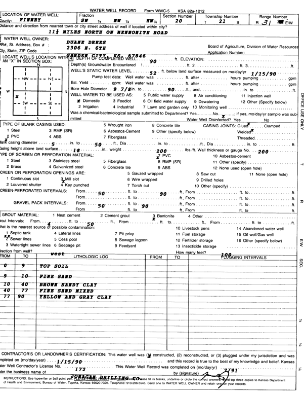
Specific Water Well Detail |
|
|
| Location Info | |||
| Owner: Drees, Duane | Status: Constructed | ||
| Location: T21S, R31W, Sec. 20, SW NW NW | County: Finney | ||
| Directions: 11.25 mi N on Mennonite Rd | |||
| Latitude: 38.2182445 | Longitude: -100.7548933 | Datum NAD 27 | |
| Latitude: 38.2182654 | Longitude: -100.7553241 | Datum NAD 83 | |
| Longitude and latitude calculated by Survey from township-range-section-quarter calls. Only good to within the quarter call accuracy. | |||
| View well on interactive map | |||
| General Info | ||
| Well Depth: 90 ft. | Elevation: ft. | |
| Static Water Level: 52 ft. | Est. Yield: gpm. | |
| Comp. Date: 15-Jan-1990 | Well Use: Domestic | |
| DWR Applic. #: | Other ID: | |
| Driller Info | ||
| Driller: Jonagan Water Well Service LLC | License #: 172 | |
| Scanned Form | View scan |
|
Chemical Sample Submitted?: No
Water Well disinfected?: | ||
| Ground water encountered: 0 ft. , 0 ft. , 0 ft. | ||
| Pump test data: Well water was 0 ft after 0 hours pumping 0 gpm | ||
| Casing Info | ||
| Casing Type: PVC
Casing Joints: |
Diam: 5 in. to 50 ft
Diam: 0 in. to 0 ft Diam: 0 in. to 0 ft | |
| Casing height above land surface: in
Casing Weight: lbs/ft Wall thickness or gauge no.: | ||
| Screen and Perforation Info | ||
| Screen Type: PVC | Screen Openings: Mill slot | |
| Screen-perforated intervals | From: 50 ft to 90 ft
From: 0 ft to 0 ft From: 0 ft to 0 ft | |
| Gravel pack intervals | From: ft to ft | |
| Grout Info | ||
| Grout used: Bentonite | From: 4 to 50 ft
From: 0 to 0 ft From: 0 to 0 ft | |
| Source of Possible Contamination | ||
| Source: Sewer lines | ||
| Direction from well: | Distance: 0 ft | |
| Lithologic Log
(Log data entered by KGS.) | ||
| From: 0 ft. to 9 ft. | top soil | |
| From: 9 ft. to 10 ft. | fine sand | |
| From: 10 ft. to 40 ft. | brown sandy clay | |
| From: 40 ft. to 77 ft. | fine sand mixed | |
| From: 77 ft. to 90 ft. | yellow and gray clay | |