|
|
|
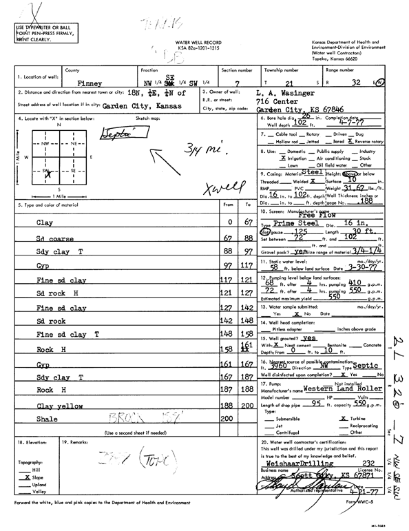
Specific Water Well Detail |
|
|
| Location Info | |||
| Owner: Wasinger, L.A. | Status: Constructed | ||
| Location: T21S, R32W, Sec. 7, NW SE SW | County: Finney | ||
| Directions: from Garden City, 18 mi N, 0.25 mi E, and 0.25 mi N | |||
| Latitude: 38.2387405 | Longitude: -100.8777139 | Datum NAD 27 | |
| Latitude: 38.2387624 | Longitude: -100.8781481 | Datum NAD 83 | |
| Longitude and latitude calculated by Survey from township-range-section-quarter calls. Only good to within the quarter call accuracy. | |||
| View well on interactive map | |||
| General Info | ||
| Well Depth: 102 ft. | Elevation: ft. | |
| Static Water Level: 58 ft. | Est. Yield: 550 gpm. | |
| Comp. Date: 07-Apr-1977 | Well Use: Irrigation | |
| DWR Applic. #: | Other ID: | |
| Driller Info | ||
| Driller: Weishaar Drilling & Supply, Inc. | License #: 232 | |
| Scanned Form | View scan |
|
Chemical Sample Submitted?: No
Water Well disinfected?: | ||
| Ground water encountered: 0 ft. , 0 ft. , 0 ft. | ||
| Pump test data: Well water was 0 ft after 0 hours pumping 0 gpm | ||
| Casing Info | ||
| Casing Type:
Casing Joints: |
Diam: 0 in. to 0 ft
Diam: 0 in. to 0 ft Diam: 0 in. to 0 ft | |
| Casing height above land surface: in
Casing Weight: lbs/ft Wall thickness or gauge no.: | ||
| Screen and Perforation Info | ||
| Screen Type: | Screen Openings: | |
| Screen-perforated intervals | From: 72 ft to 102 ft
From: 0 ft to 0 ft From: 0 ft to 0 ft | |
| Gravel pack intervals | From: ft to ft | |
| Grout Info | ||
| Grout used: | From: 0 to 0 ft
From: 0 to 0 ft From: 0 to 0 ft | |
| Source of Possible Contamination | ||
| Source: | ||
| Direction from well: | Distance: 0 ft | |
| Lithologic Log
(Log data entered by KGS.) | ||
| From: 0 ft. to 67 ft. | clay | |
| From: 67 ft. to 88 ft. | sand, coarse | |
| From: 88 ft. to 97 ft. | sandy clay tight | |
| From: 97 ft. to 117 ft. | gyp | |
| From: 117 ft. to 121 ft. | fine sand and clay | |
| From: 121 ft. to 127 ft. | sand rock, hard | |
| From: 127 ft. to 142 ft. | fine sand and clay | |
| From: 142 ft. to 148 ft. | sand rock | |
| From: 148 ft. to 158 ft. | fine sand and clay, tight | |
| From: 158 ft. to 161 ft. | rock hard | |
| From: 161 ft. to 167 ft. | gyp | |
| From: 167 ft. to 187 ft. | sandy clay, tight | |
| From: 187 ft. to 188 ft. | rock, hard | |
| From: 188 ft. to 200 ft. | clay, yellow | |
| From: 200 ft. to 200 ft. | shale | |