|
|
|
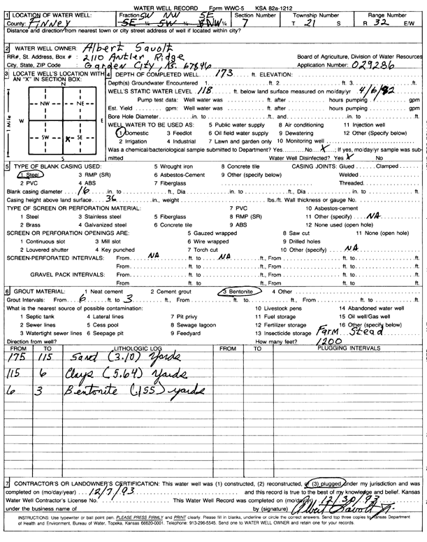
Specific Water Well Detail |
|
|
| Location Info | |||
| Owner: Savolt, Albert | Status: Plugged | ||
| Location: T21S, R32W, Sec. 7, SW NW SE | County: Finney | ||
| Directions: | |||
| Latitude: 38.2405293 | Longitude: -100.8733043 | Datum NAD 27 | |
| Latitude: 38.2405512 | Longitude: -100.8737383 | Datum NAD 83 | |
| Longitude and latitude calculated by Survey from township-range-section-quarter calls. Only good to within the quarter call accuracy. | |||
| View well on interactive map | |||
| General Info | ||
| Well Depth: 173 ft. | Elevation: ft. | |
| Static Water Level: 118 ft. | Est. Yield: gpm. | |
| Comp. Date: 07-Dec-1993 | Well Use: Domestic | |
| DWR Applic. #: 29286 | Other ID: | |
| Driller Info | ||
| Driller: well owner | License #: | |
| Scanned Form | View scan |
| Casing Info | ||
|
Casing Type: Steel
Diam: 16 in. Casing height above land surface: in | ||
| Grout Info | ||
| Grout used: Bentonite | From: 3 to 6 ft
From: 0 to 0 ft From: 0 to 0 ft | |
| Source of Possible Contamination | ||
| Source: OTHER | ||
| Direction from well: | Distance: 0 ft | |