|
|
|
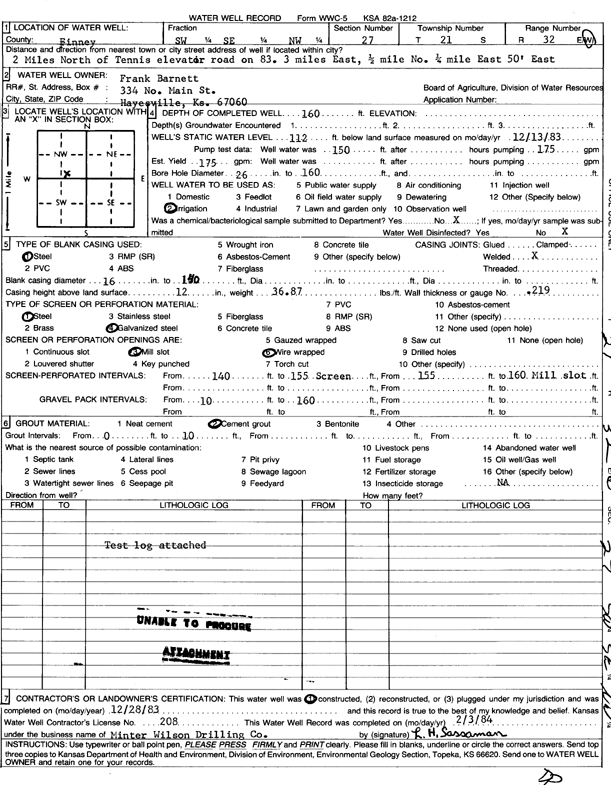
Specific Water Well Detail |
|
|
| Location Info | |||
| Owner: Barnett, Frank | Status: Constructed | ||
| Location: T21S, R32W, Sec. 27, SW SE NW | County: Finney | ||
| Directions: 2 mi N of Tennis Elevator Rd on 83, 3 E, .5 N, .25 mi E, 50 feet E | |||
| Latitude: 38.2004664 | Longitude: -100.8230437 | Datum NAD 27 | |
| Latitude: 38.2004881 | Longitude: -100.823477 | Datum NAD 83 | |
| Longitude and latitude calculated by Survey from township-range-section-quarter calls. Only good to within the quarter call accuracy. | |||
| View well on interactive map | |||
| General Info | ||
| Well Depth: 160 ft. | Elevation: ft. | |
| Static Water Level: 112 ft. | Est. Yield: 175 gpm. | |
| Comp. Date: 28-Dec-1983 | Well Use: Irrigation | |
| DWR Applic. #: | Other ID: | |
| Links | |
| View info from Wizard Water Level Data base... | |
| View info from WIMAS Water Right Data base... | |
| Driller Info | ||
| Driller: Minter-Wilson Drlg. Co., Inc. | License #: 208 | |
| Scanned Form | View scan |
|
Chemical Sample Submitted?: No
Water Well disinfected?: | ||
| Ground water encountered: 0 ft. , 0 ft. , 0 ft. | ||
| Pump test data: Well water was 150 ft after 0 hours pumping 175 gpm | ||
| Casing Info | ||
| Casing Type: Steel
Casing Joints: |
Diam: 16 in. to 140 ft
Diam: 0 in. to 0 ft Diam: 0 in. to 0 ft | |
| Casing height above land surface: in
Casing Weight: lbs/ft Wall thickness or gauge no.: | ||
| Screen and Perforation Info | ||
| Screen Type: Steel | Screen Openings: Mill slot | |
| Screen-perforated intervals | From: 140 ft to 155 ft
From: 155 ft to 160 ft From: 0 ft to 0 ft | |
| Gravel pack intervals | From: ft to ft | |
| Grout Info | ||
| Grout used: Cement grout | From: 0 to 10 ft
From: 0 to 0 ft From: 0 to 0 ft | |
| Source of Possible Contamination | ||
| Source: | ||
| Direction from well: | Distance: 0 ft | |
| Lithologic Log
(log data not edited or checked by the KGS.) | ||
| From: 0 ft. to 2 ft. | Type: CLAY | |
| From: 2 ft. to 40 ft. | Type: SANDY CLAY | |
| From: 40 ft. to 58 ft. | Type: SAND & GRAVEL | |
| From: 58 ft. to 65 ft. | Type: SANDY CLAY | |
| From: 65 ft. to 82 ft. | Type: SAND & GRAVEL | |
| From: 82 ft. to 110 ft. | Type: SANDY CLAY | |
| From: 110 ft. to 126 ft. | Type: SAND & GRAVEL | |
| From: 126 ft. to 140 ft. | Type: CLAY | |
| From: 140 ft. to 152 ft. | Type: SAND & GRAVEL | |
| From: 152 ft. to 167 ft. | Type: CLAY | |
| From: 167 ft. to 170 ft. | Type: SHALE | |