|
|
|
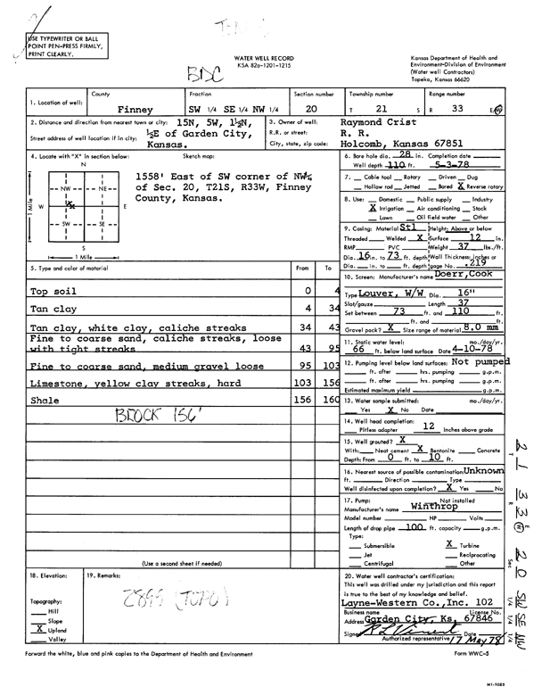
Specific Water Well Detail |
|
|
| Location Info | |||
| Owner: Crist, Raymond | Status: Constructed | ||
| Location: T21S, R33W, Sec. 20, SW SE NW | County: Finney | ||
| Directions: from Garden City, 15 mi N, 5 mi W, 1.5 mi N, and 0.5 mi E | |||
| Latitude: 38.2150091 | Longitude: -100.969417 | Datum NAD 27 | |
| Latitude: 38.215032 | Longitude: -100.9698545 | Datum NAD 83 | |
| Longitude and latitude calculated by Survey from township-range-section-quarter calls. Only good to within the quarter call accuracy. | |||
| View well on interactive map | |||
| General Info | ||
| Well Depth: 110 ft. | Elevation: ft. | |
| Static Water Level: 66 ft. | Est. Yield: gpm. | |
| Comp. Date: 03-May-1978 | Well Use: Irrigation | |
| DWR Applic. #: | Other ID: | |
| Links | |
| No Wizard information available. | |
| View info from WIMAS Water Right Data base... | |
| Driller Info | ||
| Driller: Layne-Western | License #: 102 | |
| Scanned Form | View scan |
|
Chemical Sample Submitted?: No
Water Well disinfected?: | ||
| Ground water encountered: 0 ft. , 0 ft. , 0 ft. | ||
| Pump test data: Well water was 0 ft after 0 hours pumping 0 gpm | ||
| Casing Info | ||
| Casing Type:
Casing Joints: |
Diam: 0 in. to 0 ft
Diam: 0 in. to 0 ft Diam: 0 in. to 0 ft | |
| Casing height above land surface: in
Casing Weight: lbs/ft Wall thickness or gauge no.: | ||
| Screen and Perforation Info | ||
| Screen Type: | Screen Openings: | |
| Screen-perforated intervals | From: 73 ft to 110 ft
From: 0 ft to 0 ft From: 0 ft to 0 ft | |
| Gravel pack intervals | From: ft to ft | |
| Grout Info | ||
| Grout used: | From: 0 to 0 ft
From: 0 to 0 ft From: 0 to 0 ft | |
| Source of Possible Contamination | ||
| Source: | ||
| Direction from well: | Distance: 0 ft | |
| Lithologic Log
(Log data entered by KGS.) | ||
| From: 0 ft. to 4 ft. | top soil | |
| From: 4 ft. to 34 ft. | tan clay | |
| From: 34 ft. to 43 ft. | tan clay, white clay, caliche streaks | |
| From: 43 ft. to 95 ft. | fine to coarse sand, caliche streaks, loose with tight streaks | |
| From: 95 ft. to 103 ft. | fine to coarse sand, medium gravel loose | |
| From: 103 ft. to 156 ft. | limestone, yellow clay streaks, hard | |
| From: 156 ft. to 160 ft. | shale | |