|
|
|
Specific Water Well Detail |
|
|
| Location Info | |||
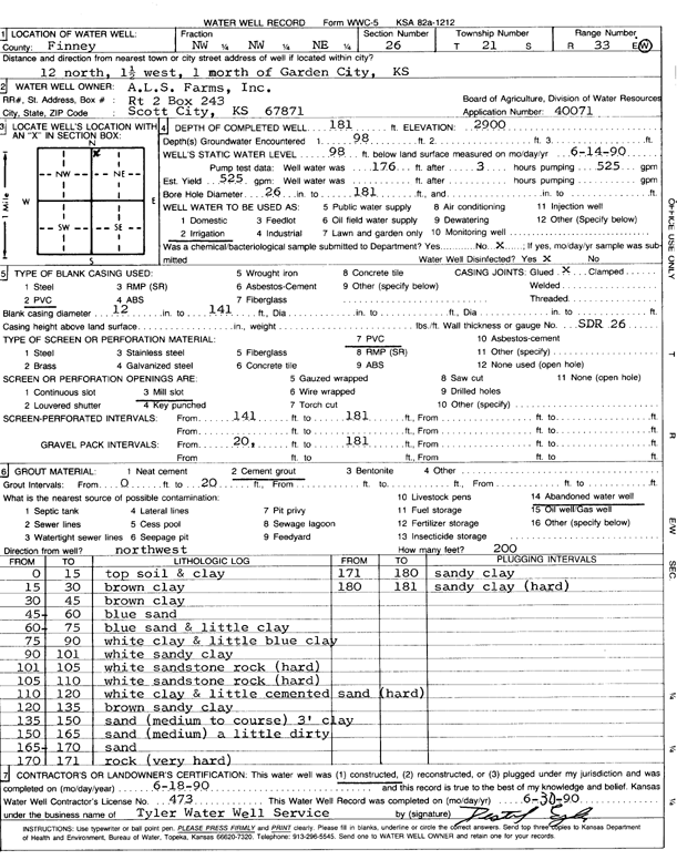
| Owner: A.L.S Farms, Inc. | Status: Constructed | ||
| Location: T21S, R33W, Sec. 26, NW NW NE | County: Finney | ||
| Directions: From Garden City, 12 mi N, 1.5 mi W, and 1 mi N | |||
| Latitude: 38.2061266 | Longitude: -100.9096018 | Datum NAD 27 | |
| Latitude: 38.2061489 | Longitude: -100.9100378 | Datum NAD 83 | |
| Longitude and latitude calculated by Survey from township-range-section-quarter calls. Only good to within the quarter call accuracy. | |||
| View well on interactive map | |||
| General Info | ||
| Well Depth: 181 ft. | Elevation: 2900 ft. | |
| Static Water Level: 98 ft. | Est. Yield: 525 gpm. | |
| Comp. Date: 18-Jun-1990 | Well Use: Irrigation | |
| DWR Applic. #: 40071 | Other ID: | |
| Links | |
| View info from Wizard Water Level Data base... | |
| View info from WIMAS Water Right Data base... | |
| Driller Info | ||
| Driller: Tyler Water Well, Inc. | License #: 473 | |
| Scanned Form | View scan |
|
Chemical Sample Submitted?: No
Water Well disinfected?: | ||
| Ground water encountered: 98 ft. , 0 ft. , 0 ft. | ||
| Pump test data: Well water was 176 ft after 3 hours pumping 525 gpm | ||
| Casing Info | ||
| Casing Type: PVC
Casing Joints: |
Diam: 12 in. to 141 ft
Diam: 0 in. to 0 ft Diam: 0 in. to 0 ft | |
| Casing height above land surface: in
Casing Weight: lbs/ft Wall thickness or gauge no.: | ||
| Screen and Perforation Info | ||
| Screen Type: PVC | Screen Openings: Mill slot | |
| Screen-perforated intervals | From: 141 ft to 181 ft
From: 0 ft to 0 ft From: 0 ft to 0 ft | |
| Gravel pack intervals | From: ft to ft | |
| Grout Info | ||
| Grout used: Cement grout | From: 0 to 20 ft
From: 0 to 0 ft From: 0 to 0 ft | |
| Source of Possible Contamination | ||
| Source: Abandoned water well | ||
| Direction from well: | Distance: 0 ft | |
| Lithologic Log
(Log data entered by KGS.) | ||
| From: 0 ft. to 15 ft. | top soil and clay | |
| From: 15 ft. to 30 ft. | brown clay | |
| From: 30 ft. to 45 ft. | brown clay | |
| From: 45 ft. to 60 ft. | blue sand | |
| From: 60 ft. to 75 ft. | blue sand and little clay | |
| From: 75 ft. to 90 ft. | white clay and little blue clay | |
| From: 90 ft. to 101 ft. | white sandy clay | |
| From: 101 ft. to 105 ft. | white sandstone rock (hard) | |
| From: 105 ft. to 110 ft. | white sandstone rock (hard) | |
| From: 110 ft. to 120 ft. | white clay and little cemented sand (hard) | |
| From: 120 ft. to 135 ft. | brown sandy clay | |
| From: 135 ft. to 150 ft. | medium to coarse sand and 3-foot clay | |
| From: 150 ft. to 165 ft. | sand (medium) a little dirty | |
| From: 165 ft. to 170 ft. | sand | |
| From: 170 ft. to 171 ft. | rock (very hard) | |
| From: 171 ft. to 180 ft. | sandy clay | |
| From: 180 ft. to 181 ft. | sandy clay (hard) | |