|
|
|
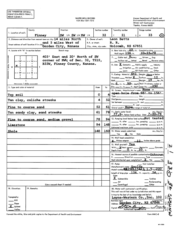
Specific Water Well Detail |
|
|
| Location Info | |||
| Owner: Betts, Leon | Status: Constructed | ||
| Location: T21S, R33W, Sec. 32, SW SW NW | County: Finney | ||
| Directions: From Garden City, 14 mi N, 5 mi W | |||
| Latitude: 38.1859977 | Longitude: -100.9739703 | Datum NAD 27 | |
| Latitude: 38.1860208 | Longitude: -100.9744088 | Datum NAD 83 | |
| Longitude and latitude calculated by Survey from township-range-section-quarter calls. Only good to within the quarter call accuracy. | |||
| View well on interactive map | |||
| General Info | ||
| Well Depth: 156 ft. | Elevation: ft. | |
| Static Water Level: 77.6 ft. | Est. Yield: gpm. | |
| Comp. Date: 23-Oct-1978 | Well Use: Domestic | |
| DWR Applic. #: | Other ID: | |
| Driller Info | ||
| Driller: Layne-Christensen Co. | License #: 102 | |
| Scanned Form | View scan |
|
Chemical Sample Submitted?: No
Water Well disinfected?: | ||
| Ground water encountered: 0 ft. , 0 ft. , 0 ft. | ||
| Pump test data: Well water was 0 ft after 0 hours pumping 0 gpm | ||
| Casing Info | ||
| Casing Type:
Casing Joints: |
Diam: 0 in. to 0 ft
Diam: 0 in. to 0 ft Diam: 0 in. to 0 ft | |
| Casing height above land surface: in
Casing Weight: lbs/ft Wall thickness or gauge no.: | ||
| Screen and Perforation Info | ||
| Screen Type: | Screen Openings: | |
| Screen-perforated intervals | From: 0 ft to 0 ft
From: 0 ft to 0 ft From: 0 ft to 0 ft | |
| Gravel pack intervals | From: ft to ft | |
| Grout Info | ||
| Grout used: | From: 0 to 0 ft
From: 0 to 0 ft From: 0 to 0 ft | |
| Source of Possible Contamination | ||
| Source: | ||
| Direction from well: | Distance: 0 ft | |
| Lithologic Log
(Log data entered by KGS.) | ||
| From: 0 ft. to 4 ft. | top soil | |
| From: 4 ft. to 52 ft. | tan clay, caliche streaks | |
| From: 52 ft. to 61 ft. | fine to coarse sand | |
| From: 61 ft. to 78 ft. | tan sandy clay, sand streaks | |
| From: 78 ft. to 94 ft. | fine to coarse sand, medium gravel | |
| From: 94 ft. to 148 ft. | limestone | |
| From: 148 ft. to 160 ft. | shale | |