|
|
|
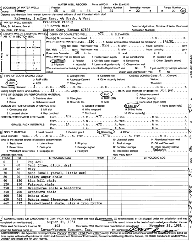
Specific Water Well Detail |
|
|
| Location Info | |||
| Owner: Finnup, Frederick | Status: Constructed | ||
| Location: T22S, R27W, Sec. 24, SW SE SE | County: Finney | ||
| Directions: from Kalvesta. 3 mi E, 4.5 mi N, and 0.5 mi W | |||
| Latitude: 38.1181285 | Longitude: -100.2287955 | Datum NAD 27 | |
| Latitude: 38.118147 | Longitude: -100.2292109 | Datum NAD 83 | |
| Longitude and latitude calculated by Survey from township-range-section-quarter calls. Only good to within the quarter call accuracy. | |||
| View well on interactive map | |||
| General Info | ||
| Well Depth: 472 ft. | Elevation: ft. | |
| Static Water Level: 320 ft. | Est. Yield: 20 gpm. | |
| Comp. Date: 31-Aug-1981 | Well Use: Domestic | |
| DWR Applic. #: | Other ID: | |
| Driller Info | ||
| Driller: Layne-Christensen Co. | License #: 102 | |
| Scanned Form | View scan |
|
Chemical Sample Submitted?: No
Water Well disinfected?: | ||
| Ground water encountered: 0 ft. , 0 ft. , 0 ft. | ||
| Pump test data: Well water was 0 ft after 0 hours pumping 0 gpm | ||
| Casing Info | ||
| Casing Type:
Casing Joints: |
Diam: 0 in. to 0 ft
Diam: 0 in. to 0 ft Diam: 0 in. to 0 ft | |
| Casing height above land surface: in
Casing Weight: lbs/ft Wall thickness or gauge no.: | ||
| Screen and Perforation Info | ||
| Screen Type: | Screen Openings: | |
| Screen-perforated intervals | From: 402 ft to 472 ft
From: 0 ft to 0 ft From: 0 ft to 0 ft | |
| Gravel pack intervals | From: ft to ft | |
| Grout Info | ||
| Grout used: | From: 0 to 0 ft
From: 0 to 0 ft From: 0 to 0 ft | |
| Source of Possible Contamination | ||
| Source: | ||
| Direction from well: | Distance: 0 ft | |
| Lithologic Log
(Log data entered by KGS.) | ||
| From: 0 ft. to 5 ft. | top soil | |
| From: 5 ft. to 60 ft. | sand (fine, dirty, dry) | |
| From: 60 ft. to 70 ft. | clay | |
| From: 70 ft. to 80 ft. | sand (small gravel, little wet) | |
| From: 80 ft. to 90 ft. | yellow shale | |
| From: 90 ft. to 120 ft. | Blue Hill shale | |
| From: 120 ft. to 250 ft. | Fairport shale | |
| From: 250 ft. to 350 ft. | Greenhorn shale and bentonite | |
| From: 350 ft. to 400 ft. | Graneros shale | |
| From: 400 ft. to 420 ft. | Dakota clay | |
| From: 420 ft. to 462 ft. | Dakota sand limestone (loose, wet) | |
| From: 462 ft. to 472 ft. | break, fissile shale, clay and iron pyrite | |