|
|
|
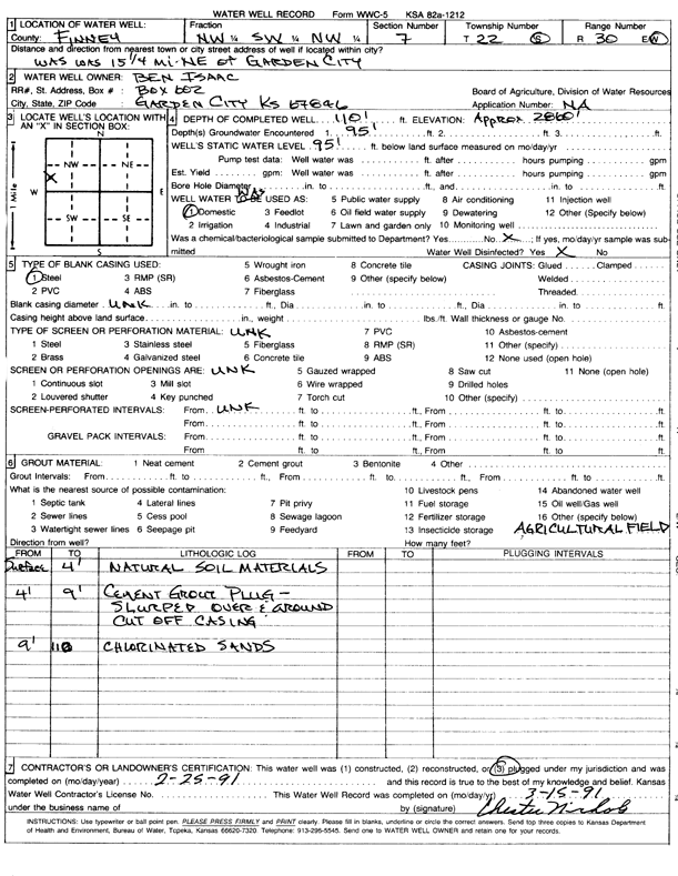
Specific Water Well Detail |
|
|
| Location Info | |||
| Owner: Isaac, Ben | Status: Plugged | ||
| Location: T22S, R30W, Sec. 7, NW SW NW | County: Finney | ||
| Directions: From Garden City, 15.25 mi NE | |||
| Latitude: 38.158008 | Longitude: -100.6628318 | Datum NAD 27 | |
| Latitude: 38.1580285 | Longitude: -100.6632606 | Datum NAD 83 | |
| Longitude and latitude calculated by Survey from township-range-section-quarter calls. Only good to within the quarter call accuracy. | |||
| View well on interactive map | |||
| General Info | ||
| Well Depth: 110 ft. | Elevation: 2860 ft. | |
| Static Water Level: 95 ft. | Est. Yield: gpm. | |
| Comp. Date: 25-Feb-1991 | Well Use: Domestic | |
| DWR Applic. #: | Other ID: | |
| Driller Info | ||
| Driller: Chester Nichols | License #: | |
| Scanned Form | View scan |
| Casing Info | ||
|
Casing Type: Steel
Diam: 5 in. Casing height above land surface: in | ||
| Grout Info | ||
| Grout used: Cement grout | From: 4 to 9 ft
From: 0 to 0 ft From: 0 to 0 ft | |
| Source of Possible Contamination | ||
| Source: OTHER | ||
| Direction from well: | Distance: 0 ft | |