|
|
|
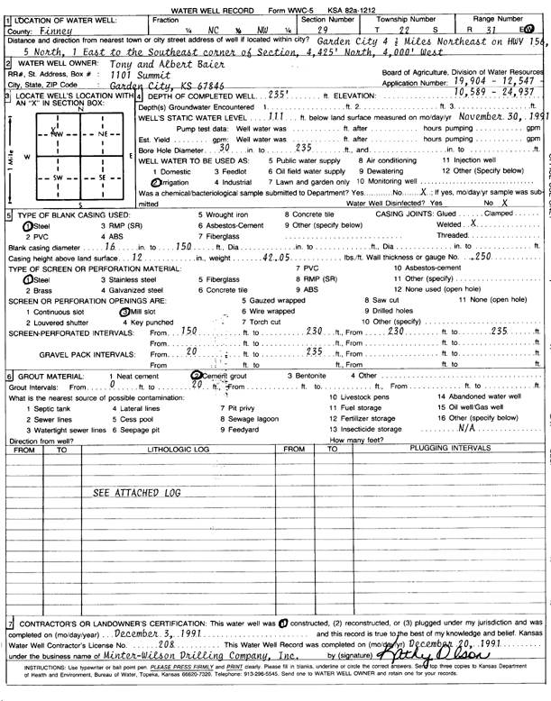
Specific Water Well Detail |
|
|
| Location Info | |||
| Owner: Baier, Tony and Albert | Status: Constructed | ||
| Location: T22S, R31W, Sec. 29, C NW | County: Finney | ||
| Directions: 4.5 mi NE on HWY 156, 5 N, 1 E to SE corner of section, 4425' N 4000' W | |||
| Latitude: 38.1157266 | Longitude: -100.7509364 | Datum NAD 27 | |
| Latitude: 38.1157478 | Longitude: -100.7513689 | Datum NAD 83 | |
| Longitude and latitude calculated by Survey from township-range-section-quarter calls. Only good to within the quarter call accuracy. | |||
| View well on interactive map | |||
| General Info | ||
| Well Depth: 235 ft. | Elevation: ft. | |
| Static Water Level: 111 ft. | Est. Yield: gpm. | |
| Comp. Date: 03-Dec-1991 | Well Use: Irrigation | |
| DWR Applic. #: 19904 | Other ID: | |
| Links | |
| No Wizard information available. | |
| View info from WIMAS Water Right Data base... | |
| Driller Info | ||
| Driller: Minter-Wilson Drlg. Co., Inc. | License #: 208 | |
| Scanned Form | View scan |
|
Chemical Sample Submitted?: No
Water Well disinfected?: | ||
| Ground water encountered: 0 ft. , 0 ft. , 0 ft. | ||
| Pump test data: Well water was 0 ft after 0 hours pumping 0 gpm | ||
| Casing Info | ||
| Casing Type: Steel
Casing Joints: |
Diam: 16 in. to 150 ft
Diam: 0 in. to 0 ft Diam: 0 in. to 0 ft | |
| Casing height above land surface: in
Casing Weight: lbs/ft Wall thickness or gauge no.: | ||
| Screen and Perforation Info | ||
| Screen Type: Steel | Screen Openings: Mill slot | |
| Screen-perforated intervals | From: 150 ft to 230 ft
From: 230 ft to 235 ft From: 0 ft to 0 ft | |
| Gravel pack intervals | From: ft to ft | |
| Grout Info | ||
| Grout used: Cement grout | From: 0 to 20 ft
From: 0 to 0 ft From: 0 to 0 ft | |
| Source of Possible Contamination | ||
| Source: OTHER | ||
| Direction from well: | Distance: 0 ft | |
| Lithologic Log
(log data not edited or checked by the KGS.) | ||
| From: 0 ft. to 10 ft. | Type: CLAY | |
| From: 10 ft. to 58 ft. | Type: SANDY CLAY | |
| From: 58 ft. to 100 ft. | Type: ROCK | |
| From: 100 ft. to 106 ft. | Type: CLAY | |
| From: 106 ft. to 115 ft. | Type: SAND & GRAVEL | |
| From: 115 ft. to 123 ft. | Type: SANDY CLAY | |
| From: 123 ft. to 128 ft. | Type: SAND & GRAVEL | |
| From: 128 ft. to 135 ft. | Type: SANDY CLAY | |
| From: 135 ft. to 150 ft. | Type: SAND & GRAVEL | |
| From: 150 ft. to 155 ft. | Type: CLAY | |
| From: 155 ft. to 161 ft. | Type: SAND & GRAVEL | |
| From: 161 ft. to 171 ft. | Type: SANDY CLAY | |
| From: 171 ft. to 174 ft. | Type: FINE SAND | |
| From: 174 ft. to 221 ft. | Type: SANDY CLAY | |
| From: 221 ft. to 227 ft. | Type: SAND & GRAVEL | |
| From: 227 ft. to 235 ft. | Type: CLAY | |
| From: 235 ft. to 240 ft. | Type: SHALE | |