|
|
|
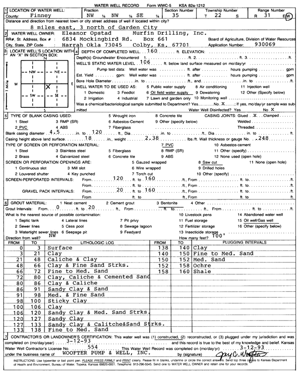
Specific Water Well Detail |
|
|
| Location Info | |||
| Owner: Opstad, Eleanor | Status: Constructed | ||
| Location: T22S, R31W, Sec. 35, NW NW SE | County: Finney | ||
| Directions: From Garden City, 8 mi E, 3 mi N | |||
| Latitude: 38.0961843 | Longitude: -100.6902047 | Datum NAD 27 | |
| Latitude: 38.0962053 | Longitude: -100.6906355 | Datum NAD 83 | |
| Longitude and latitude calculated by Survey from township-range-section-quarter calls. Only good to within the quarter call accuracy. | |||
| View well on interactive map | |||
| General Info | ||
| Well Depth: 160 ft. | Elevation: ft. | |
| Static Water Level: 106 ft. | Est. Yield: gpm. | |
| Comp. Date: 12-Mar-1993 | Well Use: Oil Field Water Supply | |
| DWR Applic. #: 930069 | Other ID: | |
| Links | |
| No Wizard information available. | |
| View info from WIMAS Water Right Data base... | |
| Driller Info | ||
| Driller: Woofter Pump & Well, Inc. | License #: 554 | |
| Scanned Form | View scan |
|
Chemical Sample Submitted?: No
Water Well disinfected?: | ||
| Ground water encountered: 0 ft. , 0 ft. , 0 ft. | ||
| Pump test data: Well water was 0 ft after 0 hours pumping 0 gpm | ||
| Casing Info | ||
| Casing Type: PVC
Casing Joints: |
Diam: 4 in. to 120 ft
Diam: 0 in. to 0 ft Diam: 0 in. to 0 ft | |
| Casing height above land surface: in
Casing Weight: lbs/ft Wall thickness or gauge no.: | ||
| Screen and Perforation Info | ||
| Screen Type: PVC | Screen Openings: Saw cut | |
| Screen-perforated intervals | From: 120 ft to 160 ft
From: 0 ft to 0 ft From: 0 ft to 0 ft | |
| Gravel pack intervals | From: ft to ft | |
| Grout Info | ||
| Grout used: Bentonite | From: 0 to 20 ft
From: 0 to 0 ft From: 0 to 0 ft | |
| Source of Possible Contamination | ||
| Source: Oil well/gas well | ||
| Direction from well: | Distance: 0 ft | |
| Lithologic Log
(Log data entered by KGS.) | ||
| From: 0 ft. to 3 ft. | surface | |
| From: 3 ft. to 21 ft. | clay | |
| From: 21 ft. to 48 ft. | caliche and clay | |
| From: 48 ft. to 66 ft. | clay and fine sand streaks | |
| From: 66 ft. to 72 ft. | fine to medium sand | |
| From: 72 ft. to 80 ft. | clay, caliche and cemented sand | |
| From: 80 ft. to 86 ft. | clay and caliche | |
| From: 86 ft. to 91 ft. | sandy clay and sand | |
| From: 91 ft. to 98 ft. | med. and fine sand | |
| From: 98 ft. to 100 ft. | sticky clay | |
| From: 100 ft. to 106 ft. | clay | |
| From: 106 ft. to 120 ft. | sandy clay and medium sand streaks | |
| From: 120 ft. to 127 ft. | sandy clay | |
| From: 127 ft. to 133 ft. | sandy clay and caliche and sand streaks | |
| From: 133 ft. to 138 ft. | fine and medium sand | |
| From: 138 ft. to 140 ft. | clay | |
| From: 140 ft. to 150 ft. | fine to medium sand | |
| From: 150 ft. to 152 ft. | medium sand | |
| From: 152 ft. to 158 ft. | ochre | |
| From: 158 ft. to 160 ft. | shale | |