|
|
|
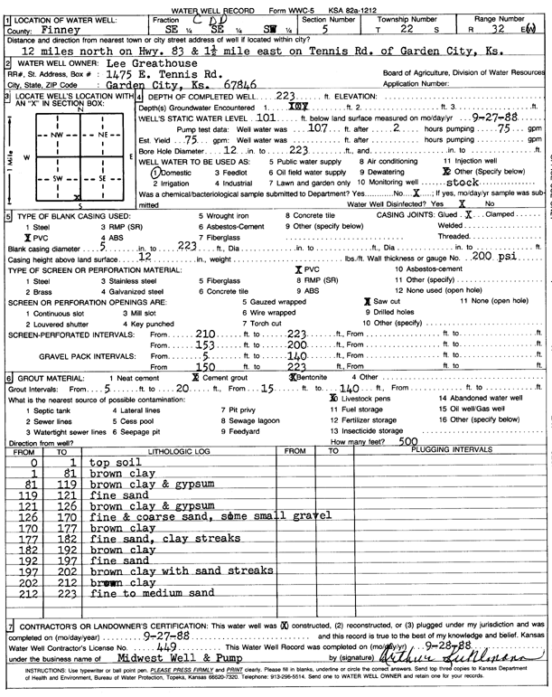
Specific Water Well Detail |
|
|
| Location Info | |||
| Owner: Greathouse, Lee | Status: Constructed | ||
| Location: T22S, R32W, Sec. 5, SE SE SW | County: Finney | ||
| Directions: from Garden City, 12 mi N on Hwy 83, 1.5 mi E on Tennis Rd | |||
| Latitude: 38.1644138 | Longitude: -100.8573209 | Datum NAD 27 | |
| Latitude: 38.1644358 | Longitude: -100.857756 | Datum NAD 83 | |
| Longitude and latitude calculated by Survey from township-range-section-quarter calls. Only good to within the quarter call accuracy. | |||
| View well on interactive map | |||
| General Info | ||
| Well Depth: 223 ft. | Elevation: ft. | |
| Static Water Level: 101 ft. | Est. Yield: 75 gpm. | |
| Comp. Date: 27-Sep-1988 | Well Use: Domestic, Livestock | |
| DWR Applic. #: | Other ID: | |
| Driller Info | ||
| Driller: Midwest Well & Pump, Inc. | License #: 449 | |
| Scanned Form | View scan |
|
Chemical Sample Submitted?: No
Water Well disinfected?: | ||
| Ground water encountered: 0 ft. , 0 ft. , 0 ft. | ||
| Pump test data: Well water was 107 ft after 2 hours pumping 75 gpm | ||
| Casing Info | ||
| Casing Type: PVC
Casing Joints: |
Diam: 5 in. to 223 ft
Diam: 0 in. to 0 ft Diam: 0 in. to 0 ft | |
| Casing height above land surface: in
Casing Weight: lbs/ft Wall thickness or gauge no.: | ||
| Screen and Perforation Info | ||
| Screen Type: PVC | Screen Openings: Saw cut | |
| Screen-perforated intervals | From: 210 ft to 223 ft
From: 153 ft to 200 ft From: 0 ft to 0 ft | |
| Gravel pack intervals | From: ft to ft | |
| Grout Info | ||
| Grout used: Cement grout, Bentonite | From: 5 to 20 ft
From: 15 to 140 ft From: 0 to 0 ft | |
| Source of Possible Contamination | ||
| Source: Livestock pens | ||
| Direction from well: | Distance: 0 ft | |
| Lithologic Log
(Log data entered by KGS.) | ||
| From: 0 ft. to 1 ft. | top soil | |
| From: 1 ft. to 81 ft. | brown clay | |
| From: 81 ft. to 119 ft. | brown clay and gypsum | |
| From: 119 ft. to 121 ft. | fine sand | |
| From: 121 ft. to 126 ft. | brown clay and gypsum | |
| From: 126 ft. to 170 ft. | fine and coarse sand, some small gravel | |
| From: 170 ft. to 177 ft. | brown clay | |
| From: 177 ft. to 182 ft. | fine sand, clay streaks | |
| From: 182 ft. to 192 ft. | brown clay | |
| From: 192 ft. to 197 ft. | fine sand | |
| From: 197 ft. to 202 ft. | brown clay with sand streaks | |
| From: 202 ft. to 212 ft. | brown clay | |
| From: 212 ft. to 223 ft. | fine to medium sand | |