|
|
|
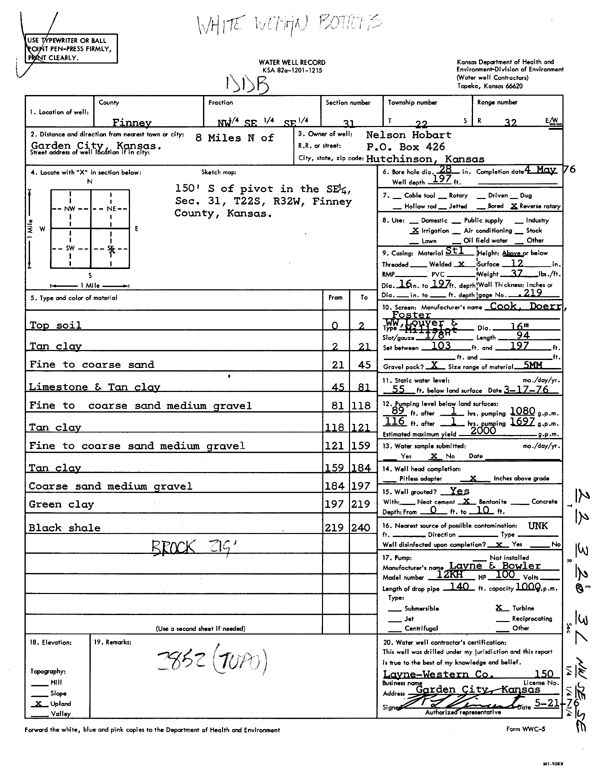
Specific Water Well Detail |
|
|
| Location Info | |||
| Owner: Hobart, Nelson | Status: Constructed | ||
| Location: T22S, R32W, Sec. 31, NW SE SE | County: Finney | ||
| Directions: from Garden City, 8 mi N | |||
| Latitude: 38.0936945 | Longitude: -100.8683727 | Datum NAD 27 | |
| Latitude: 38.093717 | Longitude: -100.8688098 | Datum NAD 83 | |
| Longitude and latitude calculated by Survey from township-range-section-quarter calls. Only good to within the quarter call accuracy. | |||
| View well on interactive map | |||
| General Info | ||
| Well Depth: 197 ft. | Elevation: ft. | |
| Static Water Level: 55 ft. | Est. Yield: 2000 gpm. | |
| Comp. Date: 04-May-1976 | Well Use: Irrigation | |
| DWR Applic. #: | Other ID: | |
| Links | |
| View info from Wizard Water Level Data base... | |
| View info from WIMAS Water Right Data base... | |
| Driller Info | ||
| Driller: Layne-Western | License #: 150 | |
| Scanned Form | View scan |
|
Chemical Sample Submitted?: No
Water Well disinfected?: | ||
| Ground water encountered: 0 ft. , 0 ft. , 0 ft. | ||
| Pump test data: Well water was 0 ft after 0 hours pumping 0 gpm | ||
| Casing Info | ||
| Casing Type:
Casing Joints: |
Diam: 0 in. to 0 ft
Diam: 0 in. to 0 ft Diam: 0 in. to 0 ft | |
| Casing height above land surface: in
Casing Weight: lbs/ft Wall thickness or gauge no.: | ||
| Screen and Perforation Info | ||
| Screen Type: | Screen Openings: | |
| Screen-perforated intervals | From: 103 ft to 197 ft
From: 0 ft to 0 ft From: 0 ft to 0 ft | |
| Gravel pack intervals | From: ft to ft | |
| Grout Info | ||
| Grout used: | From: 0 to 0 ft
From: 0 to 0 ft From: 0 to 0 ft | |
| Source of Possible Contamination | ||
| Source: | ||
| Direction from well: | Distance: 0 ft | |
| Lithologic Log
(Log data entered by KGS.) | ||
| From: 0 ft. to 2 ft. | top soil | |
| From: 2 ft. to 21 ft. | tan clay | |
| From: 21 ft. to 45 ft. | fine to coarse sand | |
| From: 45 ft. to 81 ft. | limestone and tan clay | |
| From: 81 ft. to 118 ft. | fine to coarse sand medium gravel | |
| From: 118 ft. to 121 ft. | tan clay | |
| From: 121 ft. to 159 ft. | fine to coarse sand medium gravel | |
| From: 159 ft. to 184 ft. | tan clay | |
| From: 184 ft. to 197 ft. | coarse sand medium gravel | |
| From: 197 ft. to 219 ft. | green clay | |
| From: 219 ft. to 240 ft. | black shale | |