|
|
|
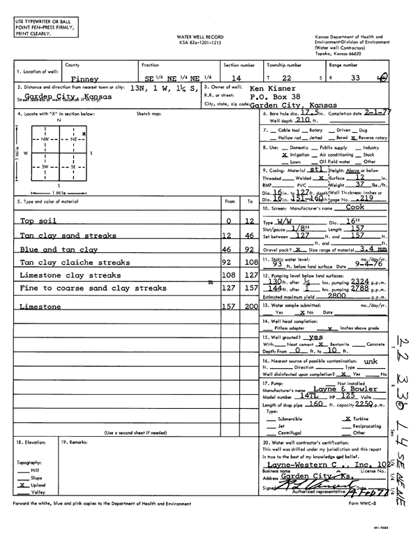
Specific Water Well Detail |
|
|
| Location Info | |||
| Owner: Kisner, Ken | Status: Constructed | ||
| Location: T22S, R33W, Sec. 14, SE NE NE | County: Finney | ||
| Directions: from Garden City, 13 mi N, 1 mi W, and 1.25 mi S | |||
| Latitude: 38.1462821 | Longitude: -100.9026157 | Datum NAD 27 | |
| Latitude: 38.1463047 | Longitude: -100.9030528 | Datum NAD 83 | |
| Longitude and latitude calculated by Survey from township-range-section-quarter calls. Only good to within the quarter call accuracy. | |||
| View well on interactive map | |||
| General Info | ||
| Well Depth: 210 ft. | Elevation: ft. | |
| Static Water Level: 93 ft. | Est. Yield: 2800 gpm. | |
| Comp. Date: 01-Feb-1977 | Well Use: Irrigation | |
| DWR Applic. #: | Other ID: | |
| Links | |
| View info from Wizard Water Level Data base... | |
| View info from WIMAS Water Right Data base... | |
| Driller Info | ||
| Driller: Layne-Christensen Co. | License #: 102 | |
| Scanned Form | View scan |
|
Chemical Sample Submitted?: No
Water Well disinfected?: | ||
| Ground water encountered: 0 ft. , 0 ft. , 0 ft. | ||
| Pump test data: Well water was 0 ft after 0 hours pumping 0 gpm | ||
| Casing Info | ||
| Casing Type:
Casing Joints: |
Diam: 0 in. to 0 ft
Diam: 0 in. to 0 ft Diam: 0 in. to 0 ft | |
| Casing height above land surface: in
Casing Weight: lbs/ft Wall thickness or gauge no.: | ||
| Screen and Perforation Info | ||
| Screen Type: | Screen Openings: | |
| Screen-perforated intervals | From: 127 ft to 157 ft
From: 0 ft to 0 ft From: 0 ft to 0 ft | |
| Gravel pack intervals | From: ft to ft | |
| Grout Info | ||
| Grout used: | From: 0 to 0 ft
From: 0 to 0 ft From: 0 to 0 ft | |
| Source of Possible Contamination | ||
| Source: | ||
| Direction from well: | Distance: 0 ft | |
| Lithologic Log
(Log data entered by KGS.) | ||
| From: 0 ft. to 12 ft. | top soil | |
| From: 12 ft. to 46 ft. | tan clay sand streaks | |
| From: 46 ft. to 92 ft. | blue and tan clay | |
| From: 92 ft. to 108 ft. | tan clay caliche streaks | |
| From: 108 ft. to 127 ft. | limestone clay streaks | |
| From: 127 ft. to 157 ft. | fine to coarse sand clay streaks | |
| From: 157 ft. to 200 ft. | limestone | |