|
|
|
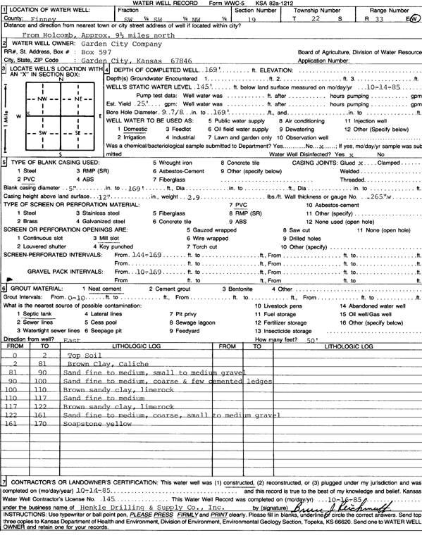
Specific Water Well Detail |
|
|
| Location Info | |||
| Owner: Garden City Co. | Status: Constructed | ||
| Location: T22S, R33W, Sec. 19, SW SW NW | County: Finney | ||
| Directions: from Holcomb: 9.5 mi N | |||
| Latitude: 38.1279759 | Longitude: -100.9914007 | Datum NAD 27 | |
| Latitude: 38.1279994 | Longitude: -100.9918414 | Datum NAD 83 | |
| Longitude and latitude calculated by Survey from township-range-section-quarter calls. Only good to within the quarter call accuracy. | |||
| View well on interactive map | |||
| General Info | ||
| Well Depth: 169 ft. | Elevation: ft. | |
| Static Water Level: 145 ft. | Est. Yield: 25 gpm. | |
| Comp. Date: 14-Oct-1985 | Well Use: Domestic | |
| DWR Applic. #: | Other ID: | |
| Driller Info | ||
| Driller: Hydro Res. Mid Continent #145 | License #: 145 | |
| Scanned Form | View scan |
|
Chemical Sample Submitted?: No
Water Well disinfected?: | ||
| Ground water encountered: 0 ft. , 0 ft. , 0 ft. | ||
| Pump test data: Well water was 0 ft after 0 hours pumping 0 gpm | ||
| Casing Info | ||
| Casing Type: PVC
Casing Joints: |
Diam: 5 in. to 169 ft
Diam: 0 in. to 0 ft Diam: 0 in. to 0 ft | |
| Casing height above land surface: in
Casing Weight: lbs/ft Wall thickness or gauge no.: | ||
| Screen and Perforation Info | ||
| Screen Type: PVC | Screen Openings: Mill slot | |
| Screen-perforated intervals | From: 144 ft to 169 ft
From: 0 ft to 0 ft From: 0 ft to 0 ft | |
| Gravel pack intervals | From: ft to ft | |
| Grout Info | ||
| Grout used: Neat cement | From: 0 to 10 ft
From: 0 to 0 ft From: 0 to 0 ft | |
| Source of Possible Contamination | ||
| Source: Septic Tank | ||
| Direction from well: | Distance: 0 ft | |
| Lithologic Log
(Log data entered by KGS.) | ||
| From: 0 ft. to 2 ft. | top soil | |
| From: 2 ft. to 81 ft. | brown clay, caliche | |
| From: 81 ft. to 90 ft. | sand fine to medium, small to medium gravel | |
| From: 90 ft. to 100 ft. | sand fine to medium, coarse and few cemented ledges | |
| From: 100 ft. to 110 ft. | brown sandy clay, limerock | |
| From: 110 ft. to 117 ft. | sand fine to medium | |
| From: 117 ft. to 122 ft. | brown sandy clay, limerock | |
| From: 122 ft. to 161 ft. | sand fine to medium, coarse, small to medium gravel | |
| From: 161 ft. to 170 ft. | soapstone yellow | |