|
|
|
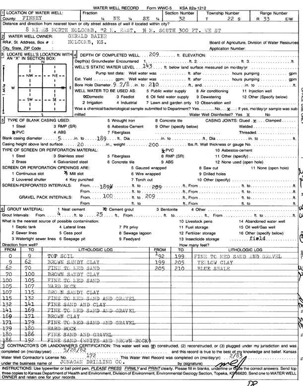
Specific Water Well Detail |
|
|
| Location Info | |||
| Owner: Baier, Gerald | Status: Constructed | ||
| Location: T22S, R33W, Sec. 32, NE SE | County: Finney | ||
| Directions: from Holcomb, 8 mi N, 2 mi E, .5 mi S, 300 feet W | |||
| Latitude: 38.0962823 | Longitude: -100.9586617 | Datum NAD 27 | |
| Latitude: 38.0963057 | Longitude: -100.959102 | Datum NAD 83 | |
| Longitude and latitude calculated by Survey from township-range-section-quarter calls. Only good to within the quarter call accuracy. | |||
| View well on interactive map | |||
| General Info | ||
| Well Depth: 209 ft. | Elevation: ft. | |
| Static Water Level: 143 ft. | Est. Yield: gpm. | |
| Comp. Date: 28-May-1982 | Well Use: Domestic | |
| DWR Applic. #: | Other ID: | |
| Driller Info | ||
| Driller: Jonagan Water Well Service LLC | License #: 172 | |
| Scanned Form | View scan |
|
Chemical Sample Submitted?: No
Water Well disinfected?: | ||
| Ground water encountered: 0 ft. , 0 ft. , 0 ft. | ||
| Pump test data: Well water was 0 ft after 0 hours pumping 0 gpm | ||
| Casing Info | ||
| Casing Type:
Casing Joints: |
Diam: 0 in. to 0 ft
Diam: 0 in. to 0 ft Diam: 0 in. to 0 ft | |
| Casing height above land surface: in
Casing Weight: lbs/ft Wall thickness or gauge no.: | ||
| Screen and Perforation Info | ||
| Screen Type: | Screen Openings: | |
| Screen-perforated intervals | From: 189 ft to 259 ft
From: 0 ft to 0 ft From: 0 ft to 0 ft | |
| Gravel pack intervals | From: ft to ft | |
| Grout Info | ||
| Grout used: | From: 0 to 0 ft
From: 0 to 0 ft From: 0 to 0 ft | |
| Source of Possible Contamination | ||
| Source: | ||
| Direction from well: | Distance: 0 ft | |
| Lithologic Log
(Log data entered by KGS.) | ||
| From: 0 ft. to 9 ft. | top soil | |
| From: 9 ft. to 62 ft. | brown sandy clay | |
| From: 62 ft. to 70 ft. | fine to medium sand | |
| From: 70 ft. to 100 ft. | brown sandy clay | |
| From: 100 ft. to 105 ft. | fine to medium sand | |
| From: 105 ft. to 107 ft. | hard rock | |
| From: 107 ft. to 115 ft. | brown sandy clay | |
| From: 115 ft. to 132 ft. | fine to medium sand and gravel | |
| From: 132 ft. to 141 ft. | fine sand and clay | |
| From: 141 ft. to 169 ft. | fine to medium sand and gravel | |
| From: 169 ft. to 171 ft. | brown clay | |
| From: 171 ft. to 179 ft. | fine to medium sand and gravel | |
| From: 179 ft. to 180 ft. | hard rock | |
| From: 180 ft. to 186 ft. | fine sand and gravel | |
| From: 186 ft. to 192 ft. | fine sand (white and brown rock) | |
| From: 192 ft. to 199 ft. | fine to medium sand and gravel | |
| From: 199 ft. to 205 ft. | yellow clay | |
| From: 205 ft. to 210 ft. | blue shale | |