|
|
|
Specific Water Well Detail |
|
|
| Location Info | |||
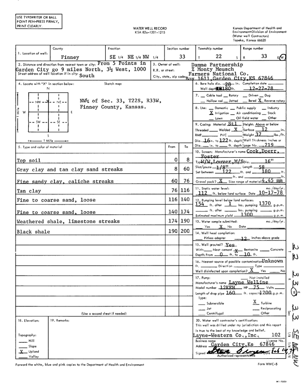
| Owner: Damme Partnership | Status: Constructed | ||
| Location: T22S, R33W, Sec. 33, SE NE NW | County: Finney | ||
| Directions: from 5 Points in Garden City, 9 mi N, 3.5 mi W, and 1000 feet S | |||
| Latitude: 38.1026212 | Longitude: -100.94837 | Datum NAD 27 | |
| Latitude: 38.1026445 | Longitude: -100.9488098 | Datum NAD 83 | |
| Longitude and latitude calculated by Survey from township-range-section-quarter calls. Only good to within the quarter call accuracy. | |||
| View well on interactive map | |||
| General Info | ||
| Well Depth: 180 ft. | Elevation: ft. | |
| Static Water Level: 112 ft. | Est. Yield: 1300 gpm. | |
| Comp. Date: 27-Dec-1978 | Well Use: Irrigation | |
| DWR Applic. #: | Other ID: | |
| Links | |
| View info from Wizard Water Level Data base... | |
| View info from WIMAS Water Right Data base... | |
| Driller Info | ||
| Driller: Layne-Western Co. | License #: 102 | |
| Scanned Form | View scan |
|
Chemical Sample Submitted?: No
Water Well disinfected?: | ||
| Ground water encountered: 0 ft. , 0 ft. , 0 ft. | ||
| Pump test data: Well water was 0 ft after 0 hours pumping 0 gpm | ||
| Casing Info | ||
| Casing Type:
Casing Joints: |
Diam: 0 in. to 0 ft
Diam: 0 in. to 0 ft Diam: 0 in. to 0 ft | |
| Casing height above land surface: in
Casing Weight: lbs/ft Wall thickness or gauge no.: | ||
| Screen and Perforation Info | ||
| Screen Type: | Screen Openings: | |
| Screen-perforated intervals | From: 122 ft to 180 ft
From: 0 ft to 0 ft From: 0 ft to 0 ft | |
| Gravel pack intervals | From: ft to ft | |
| Grout Info | ||
| Grout used: | From: 0 to 0 ft
From: 0 to 0 ft From: 0 to 0 ft | |
| Source of Possible Contamination | ||
| Source: | ||
| Direction from well: | Distance: 0 ft | |
| Lithologic Log
(Log data entered by KGS.) | ||
| From: 0 ft. to 8 ft. | top soil | |
| From: 8 ft. to 60 ft. | gray clay and tan clay sand streaks | |
| From: 60 ft. to 76 ft. | fine sandy clay, caliche streaks | |
| From: 76 ft. to 116 ft. | tan clay | |
| From: 116 ft. to 140 ft. | fine to coarse sand, loose | |
| From: 140 ft. to 174 ft. | fine to coarse sand, loose | |
| From: 174 ft. to 190 ft. | weathered shale, limestone streaks | |
| From: 190 ft. to 200 ft. | black shale | |