|
|
|
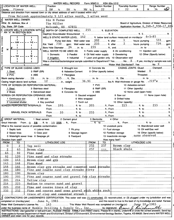
Specific Water Well Detail |
|
|
| Location Info | |||
| Owner: Six M Farms | Status: Constructed | ||
| Location: T22S, R34W, Sec. 22, SW SW NW | County: Finney | ||
| Directions: from Holcomb: 9.5 mi N and 3 mi W | |||
| Latitude: 38.1278106 | Longitude: -101.046591 | Datum NAD 27 | |
| Latitude: 38.1278337 | Longitude: -101.0470324 | Datum NAD 83 | |
| Longitude and latitude calculated by Survey from township-range-section-quarter calls. Only good to within the quarter call accuracy. | |||
| View well on interactive map | |||
| General Info | ||
| Well Depth: 255 ft. | Elevation: ft. | |
| Static Water Level: 142 ft. | Est. Yield: 750 gpm. | |
| Comp. Date: 06-Jun-1985 | Well Use: Irrigation | |
| DWR Applic. #: 6248, 7958, 17694 | Other ID: | |
| Links | |
| No Wizard information available. | |
| View info from WIMAS Water Right Data base... | |
| Driller Info | ||
| Driller: Hydro Resources Mid Continent, Inc. | License #: 145 | |
| Scanned Form | View scan |
|
Chemical Sample Submitted?: No
Water Well disinfected?: | ||
| Ground water encountered: 0 ft. , 0 ft. , 0 ft. | ||
| Pump test data: Well water was 202 ft after 1 hours pumping 533 gpm | ||
| Casing Info | ||
| Casing Type: Steel
Casing Joints: |
Diam: 16 in. to 255 ft
Diam: 0 in. to 0 ft Diam: 0 in. to 0 ft | |
| Casing height above land surface: in
Casing Weight: lbs/ft Wall thickness or gauge no.: | ||
| Screen and Perforation Info | ||
| Screen Type: Steel | Screen Openings: Continuous slot | |
| Screen-perforated intervals | From: 195 ft to 205 ft
From: 215 ft to 255 ft From: 0 ft to 0 ft | |
| Gravel pack intervals | From: ft to ft | |
| Grout Info | ||
| Grout used: Bentonite | From: 0 to 10 ft
From: 0 to 0 ft From: 0 to 0 ft | |
| Source of Possible Contamination | ||
| Source: OTHER | ||
| Direction from well: | Distance: 0 ft | |
| Lithologic Log
(Log data entered by KGS.) | ||
| From: 0 ft. to 2 ft. | top soil | |
| From: 2 ft. to 65 ft. | brown clay | |
| From: 65 ft. to 92 ft. | fine sand | |
| From: 92 ft. to 120 ft. | fine sand and clay streaks | |
| From: 120 ft. to 143 ft. | brown clay and gyp | |
| From: 143 ft. to 148 ft. | fine sand | |
| From: 148 ft. to 164 ft. | brown clay gyp streaks and cemented sand streaks | |
| From: 164 ft. to 180 ft. | fine and coarse sand clay streaks dirty | |
| From: 180 ft. to 190 ft. | brown clay | |
| From: 190 ft. to 205 ft. | fine and coarse sand and gravel few clay streaks | |
| From: 205 ft. to 214 ft. | yellow clay | |
| From: 214 ft. to 225 ft. | medium to coarse sand and gravel | |
| From: 225 ft. to 232 ft. | fine and coarse trace of clay | |
| From: 232 ft. to 252 ft. | fine and coarse sand some gravel with white rock trace of clay and cemented streak | |
| From: 252 ft. to 257 ft. | brown clay | |
| From: 257 ft. to 257 ft. | black shale | |