|
|
|
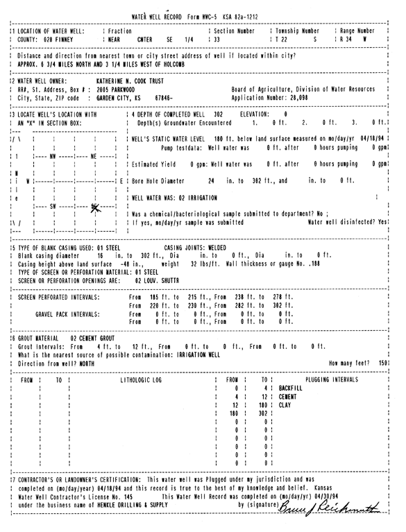
Specific Water Well Detail |
|
|
| Location Info | |||
| Owner: Katherine N. Cook Trust | Status: Plugged | ||
| Location: T22S, R34W, Sec. 33, NC SE | County: Finney | ||
| Directions: from Holcomb, 6.75 mi N and 3.25 mi W | |||
| Latitude: 38.0959574 | Longitude: -101.0519723 | Datum NAD 27 | |
| Latitude: 38.0959805 | Longitude: -101.0524148 | Datum NAD 83 | |
| Longitude and latitude calculated by Survey from township-range-section-quarter calls. Only good to within the quarter call accuracy. | |||
| View well on interactive map | |||
| General Info | ||
| Well Depth: 302 ft. | Elevation: ft. | |
| Static Water Level: 180 ft. | Est. Yield: gpm. | |
| Comp. Date: 18-Apr-1994 | Well Use: Irrigation | |
| DWR Applic. #: 28098 | Other ID: | |
| Links | |
| No Wizard information available. | |
| View info from WIMAS Water Right Data base... | |
| Driller Info | ||
| Driller: Hydro Res. Mid Continent #145 | License #: 145 | |
| Scanned Form | View scan |
| Casing Info | ||
|
Casing Type: Steel
Diam: 16 in. Casing height above land surface: in | ||
| Grout Info | ||
| Grout used: Cement grout | From: 4 to 12 ft
From: 0 to 0 ft From: 0 to 0 ft | |
| Source of Possible Contamination | ||
| Source: OTHER | ||
| Direction from well: | Distance: 0 ft | |