|
|
|
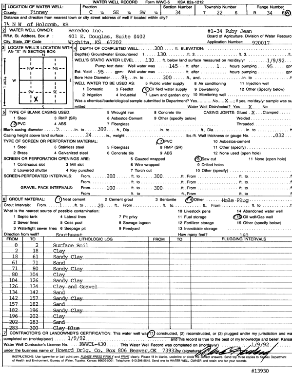
Specific Water Well Detail |
|
|
| Location Info | |||
| Owner: Beredco, Inc. | Status: Constructed | ||
| Location: T22S, R34W, Sec. 34, C SE SW | County: Finney | ||
| Directions: from Holcomb, 7.5 mi NW | |||
| Latitude: 38.0923925 | Longitude: -101.0404487 | Datum NAD 27 | |
| Latitude: 38.0924158 | Longitude: -101.0408911 | Datum NAD 83 | |
| Longitude and latitude calculated by Survey from township-range-section-quarter calls. Only good to within the quarter call accuracy. | |||
| View well on interactive map | |||
| General Info | ||
| Well Depth: 300 ft. | Elevation: ft. | |
| Static Water Level: 130 ft. | Est. Yield: 95 gpm. | |
| Comp. Date: 09-Jan-1992 | Well Use: Oil Field Water Supply | |
| DWR Applic. #: 920017 | Other ID: Ruby Jean 1-34 | |
| Driller Info | ||
| Driller: Howard Drilling Co. | License #: 430 | |
| Scanned Form | View scan |
|
Chemical Sample Submitted?: No
Water Well disinfected?: | ||
| Ground water encountered: 130 ft. , 0 ft. , 0 ft. | ||
| Pump test data: Well water was 145 ft after 1 hours pumping 95 gpm | ||
| Casing Info | ||
| Casing Type: PVC
Casing Joints: |
Diam: 5 in. to 300 ft
Diam: 0 in. to 0 ft Diam: 0 in. to 0 ft | |
| Casing height above land surface: in
Casing Weight: lbs/ft Wall thickness or gauge no.: | ||
| Screen and Perforation Info | ||
| Screen Type: PVC | Screen Openings: Saw cut | |
| Screen-perforated intervals | From: 200 ft to 300 ft
From: 0 ft to 0 ft From: 0 ft to 0 ft | |
| Gravel pack intervals | From: ft to ft | |
| Grout Info | ||
| Grout used: Neat cement, | From: 1 to 20 ft
From: 0 to 0 ft From: 0 to 0 ft | |
| Source of Possible Contamination | ||
| Source: Oil well/gas well | ||
| Direction from well: | Distance: 0 ft | |
| Lithologic Log
(Log data entered by KGS.) | ||
| From: 0 ft. to 2 ft. | surface soil | |
| From: 2 ft. to 18 ft. | clay | |
| From: 18 ft. to 61 ft. | sandy clay | |
| From: 61 ft. to 71 ft. | sand | |
| From: 71 ft. to 80 ft. | sandy clay | |
| From: 80 ft. to 104 ft. | clay | |
| From: 104 ft. to 126 ft. | sandy clay | |
| From: 126 ft. to 134 ft. | clay and gravel | |
| From: 134 ft. to 142 ft. | sand | |
| From: 142 ft. to 157 ft. | sandy clay | |
| From: 157 ft. to 182 ft. | sand | |
| From: 182 ft. to 196 ft. | sandy clay | |
| From: 196 ft. to 202 ft. | clay | |
| From: 202 ft. to 283 ft. | sand | |
| From: 283 ft. to 300 ft. | clay blue | |