|
|
|
Specific Water Well Detail |
|
|
| Location Info | |||
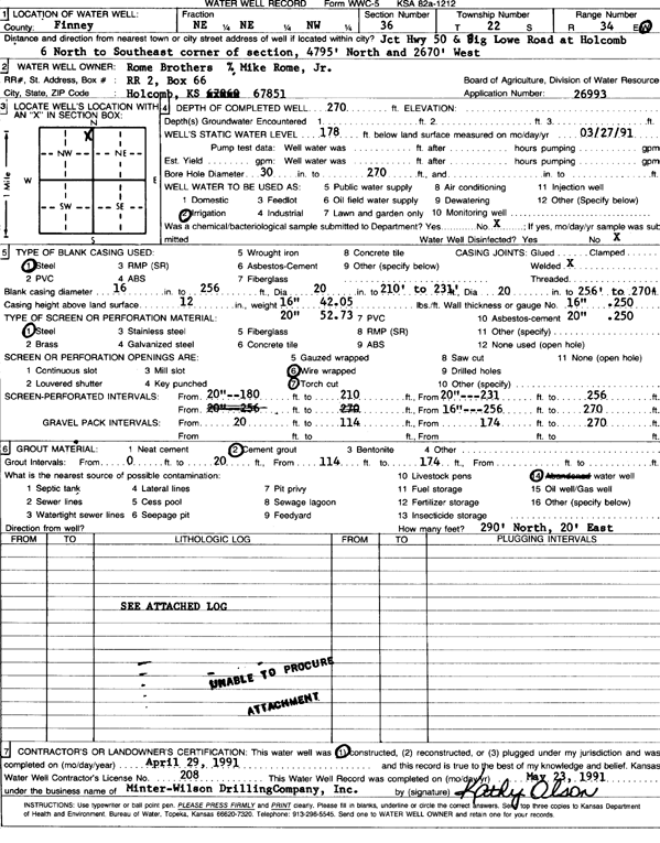
| Owner: Rome Brothers | Status: Constructed | ||
| Location: T22S, R34W, Sec. 36, NE NE NW | County: Finney | ||
| Directions: Jct Hwy 50 and Big Lowe Rd: 6 mi N to SE corner of section, 4795 feet N and 2670 feet W | |||
| Latitude: 38.1043328 | Longitude: -101.0026704 | Datum NAD 27 | |
| Latitude: 38.1043565 | Longitude: -101.003112 | Datum NAD 83 | |
| Longitude and latitude calculated by Survey from township-range-section-quarter calls. Only good to within the quarter call accuracy. | |||
| View well on interactive map | |||
| General Info | ||
| Well Depth: 270 ft. | Elevation: ft. | |
| Static Water Level: 178 ft. | Est. Yield: gpm. | |
| Comp. Date: 29-Apr-1991 | Well Use: Irrigation | |
| DWR Applic. #: 26993 | Other ID: | |
| Links | |
| No Wizard information available. | |
| View info from WIMAS Water Right Data base... | |
| Driller Info | ||
| Driller: MW Drilling | License #: 208 | |
| Scanned Form | View scan |
|
Chemical Sample Submitted?: No
Water Well disinfected?: | ||
| Ground water encountered: 0 ft. , 0 ft. , 0 ft. | ||
| Pump test data: Well water was 0 ft after 0 hours pumping 0 gpm | ||
| Casing Info | ||
| Casing Type: Steel
Casing Joints: |
Diam: 16 in. to 256 ft
Diam: 20 in. to 210 ft Diam: 20 in. to 256 ft | |
| Casing height above land surface: in
Casing Weight: lbs/ft Wall thickness or gauge no.: | ||
| Screen and Perforation Info | ||
| Screen Type: Concrete Tile | Screen Openings: Torch cut | |
| Screen-perforated intervals | From: 20 ft to 180 ft
From: 20 ft to 210 ft From: 20 ft to 231 ft | |
| Gravel pack intervals | From: ft to ft | |
| Grout Info | ||
| Grout used: Cement grout | From: 0 to 20 ft
From: 114 to 174 ft From: 0 to 0 ft | |
| Source of Possible Contamination | ||
| Source: Abandoned water well | ||
| Direction from well: | Distance: 0 ft | |
| Lithologic Log
(log data not edited or checked by the KGS.) | ||
| From: 0 ft. to 10 ft. | Type: CLAY | |
| From: 10 ft. to 18 ft. | Type: MEDIUM SAND | |
| From: 18 ft. to 20 ft. | Type: CLAY | |
| From: 20 ft. to 33 ft. | Type: MEDIUM SAND | |
| From: 33 ft. to 174 ft. | Type: CLAY | |
| From: 174 ft. to 186 ft. | Type: MEDIUM SAND | |
| From: 186 ft. to 208 ft. | Type: SAND & GRAVEL | |
| From: 208 ft. to 232 ft. | Type: CLAY | |
| From: 232 ft. to 255 ft. | Type: SAND & GRAVEL | |
| From: 255 ft. to 268 ft. | Type: CLAY | |
| From: 268 ft. to 275 ft. | Type: SHALE | |