|
|
|
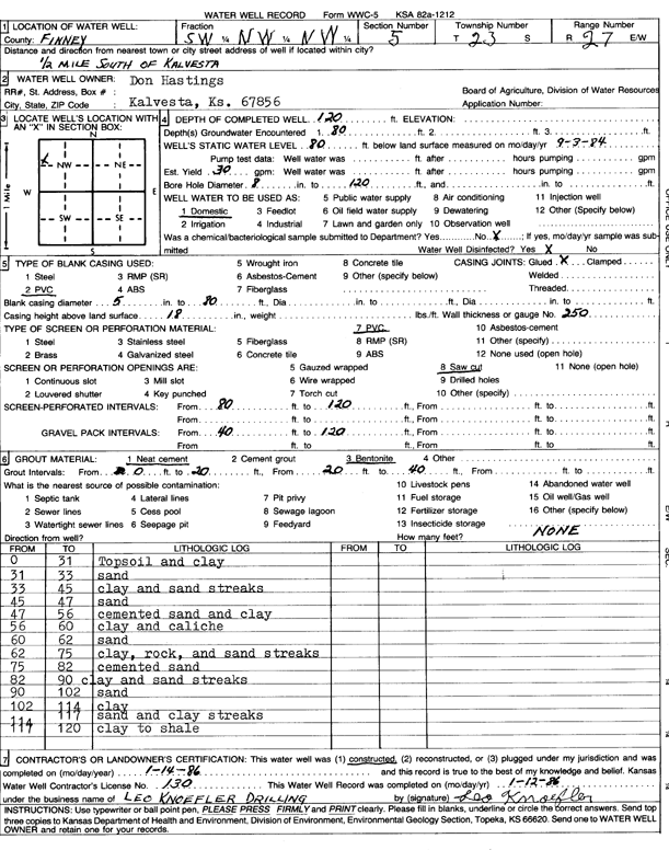
Specific Water Well Detail |
|
|
| Location Info | |||
| Owner: Hastings, Don | Status: Constructed | ||
| Location: T23S, R27W, Sec. 5, SW NW NW | County: Finney | ||
| Directions: from Kalvesta, 0.5 mi S | |||
| Latitude: 38.0852054 | Longitude: -100.3155272 | Datum NAD 27 | |
| Latitude: 38.0852245 | Longitude: -100.3159457 | Datum NAD 83 | |
| Longitude and latitude calculated by Survey from township-range-section-quarter calls. Only good to within the quarter call accuracy. | |||
| View well on interactive map | |||
| General Info | ||
| Well Depth: 120 ft. | Elevation: ft. | |
| Static Water Level: 80 ft. | Est. Yield: 30 gpm. | |
| Comp. Date: 14-Jan-1986 | Well Use: Domestic | |
| DWR Applic. #: | Other ID: | |
| Driller Info | ||
| Driller: Leo Knoefler Drilling | License #: 130 | |
| Scanned Form | View scan |
|
Chemical Sample Submitted?: No
Water Well disinfected?: | ||
| Ground water encountered: 80 ft. , 0 ft. , 0 ft. | ||
| Pump test data: Well water was 0 ft after 0 hours pumping 0 gpm | ||
| Casing Info | ||
| Casing Type: PVC
Casing Joints: |
Diam: 5 in. to 80 ft
Diam: 0 in. to 0 ft Diam: 0 in. to 0 ft | |
| Casing height above land surface: in
Casing Weight: lbs/ft Wall thickness or gauge no.: | ||
| Screen and Perforation Info | ||
| Screen Type: PVC | Screen Openings: Saw cut | |
| Screen-perforated intervals | From: 80 ft to 120 ft
From: 0 ft to 0 ft From: 0 ft to 0 ft | |
| Gravel pack intervals | From: ft to ft | |
| Grout Info | ||
| Grout used: Neat cement, Bentonite | From: 0 to 20 ft
From: 20 to 40 ft From: 0 to 0 ft | |
| Source of Possible Contamination | ||
| Source: | ||
| Direction from well: | Distance: 0 ft | |
| Lithologic Log
(Log data entered by KGS.) | ||
| From: 0 ft. to 31 ft. | topsoil and clay | |
| From: 31 ft. to 33 ft. | sand | |
| From: 33 ft. to 45 ft. | clay and sand streaks | |
| From: 45 ft. to 47 ft. | sand | |
| From: 47 ft. to 56 ft. | cemented sand and clay | |
| From: 56 ft. to 60 ft. | clay and caliche | |
| From: 60 ft. to 62 ft. | sand | |
| From: 62 ft. to 75 ft. | clay, rock, and sand streaks | |
| From: 75 ft. to 82 ft. | cemented sand | |
| From: 82 ft. to 90 ft. | clay and sand streaks | |
| From: 90 ft. to 102 ft. | sand | |
| From: 102 ft. to 114 ft. | clay | |
| From: 114 ft. to 117 ft. | sand and clay streaks | |
| From: 117 ft. to 120 ft. | clay to shale | |