|
|
|
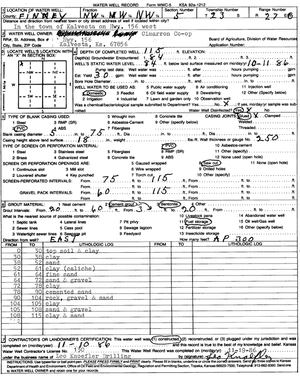
Specific Water Well Detail |
|
|
| Location Info | |||
| Owner: Cimarron Co-op | Status: Constructed | ||
| Location: T23S, R27W, Sec. 5, NW NW NW | County: Finney | ||
| Directions: in Kalvesta on Hwy 156 W | |||
| Latitude: 38.0870039 | Longitude: -100.3155047 | Datum NAD 27 | |
| Latitude: 38.087023 | Longitude: -100.3159232 | Datum NAD 83 | |
| Longitude and latitude calculated by Survey from township-range-section-quarter calls. Only good to within the quarter call accuracy. | |||
| View well on interactive map | |||
| General Info | ||
| Well Depth: 115 ft. | Elevation: ft. | |
| Static Water Level: 84 ft. | Est. Yield: 30 gpm. | |
| Comp. Date: 10-Nov-1986 | Well Use: Domestic | |
| DWR Applic. #: | Other ID: | |
| Driller Info | ||
| Driller: Leo Knoefler Drilling | License #: 130 | |
| Scanned Form | View scan |
|
Chemical Sample Submitted?: No
Water Well disinfected?: | ||
| Ground water encountered: 84 ft. , 0 ft. , 0 ft. | ||
| Pump test data: Well water was 0 ft after 0 hours pumping 0 gpm | ||
| Casing Info | ||
| Casing Type: PVC
Casing Joints: |
Diam: 5 in. to 75 ft
Diam: 0 in. to 0 ft Diam: 0 in. to 0 ft | |
| Casing height above land surface: in
Casing Weight: lbs/ft Wall thickness or gauge no.: | ||
| Screen and Perforation Info | ||
| Screen Type: PVC | Screen Openings: Saw cut | |
| Screen-perforated intervals | From: 75 ft to 115 ft
From: 0 ft to 0 ft From: 0 ft to 0 ft | |
| Gravel pack intervals | From: ft to ft | |
| Grout Info | ||
| Grout used: Cement grout, Bentonite | From: 20 to 60 ft
From: 3 to 20 ft From: 0 to 0 ft | |
| Source of Possible Contamination | ||
| Source: Fuel storage | ||
| Direction from well: | Distance: 0 ft | |
| Lithologic Log
(Log data entered by KGS.) | ||
| From: 0 ft. to 30 ft. | top soil and clay | |
| From: 30 ft. to 38 ft. | clay | |
| From: 38 ft. to 52 ft. | sand | |
| From: 52 ft. to 61 ft. | clay (caliche) | |
| From: 61 ft. to 64 ft. | fine sand | |
| From: 64 ft. to 72 ft. | sand and gravel | |
| From: 72 ft. to 78 ft. | clay | |
| From: 78 ft. to 90 ft. | cemented sand | |
| From: 90 ft. to 104 ft. | rock, gravel and sand | |
| From: 104 ft. to 105 ft. | clay | |
| From: 105 ft. to 108 ft. | sand and gravel | |
| From: 108 ft. to 115 ft. | clay and sand | |