|
|
|
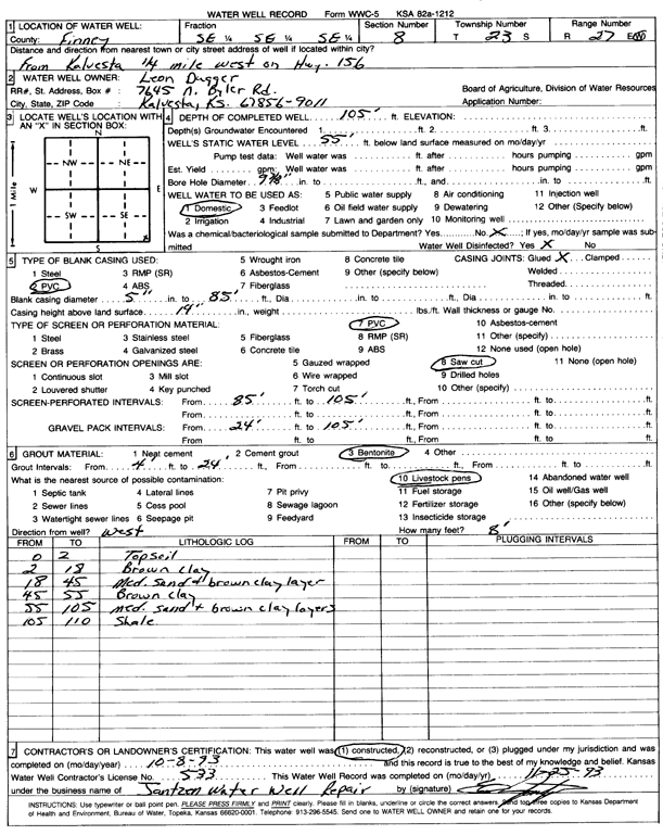
Specific Water Well Detail |
|
|
| Location Info | |||
| Owner: Dugger, Leon | Status: Constructed | ||
| Location: T23S, R27W, Sec. 8, SE SE SE | County: Finney | ||
| Directions: from Kalvesta: 0.25 mi W on HWY 156 | |||
| Latitude: 38.0598856 | Longitude: -100.299853 | Datum NAD 27 | |
| Latitude: 38.0599049 | Longitude: -100.3002714 | Datum NAD 83 | |
| Longitude and latitude calculated by Survey from township-range-section-quarter calls. Only good to within the quarter call accuracy. | |||
| View well on interactive map | |||
| General Info | ||
| Well Depth: 105 ft. | Elevation: ft. | |
| Static Water Level: 55 ft. | Est. Yield: gpm. | |
| Comp. Date: 08-Oct-1993 | Well Use: Domestic | |
| DWR Applic. #: | Other ID: | |
| Driller Info | ||
| Driller: Jantzen Water Well | License #: 533 | |
| Scanned Form | View scan |
|
Chemical Sample Submitted?: No
Water Well disinfected?: | ||
| Ground water encountered: 0 ft. , 0 ft. , 0 ft. | ||
| Pump test data: Well water was 0 ft after 0 hours pumping 0 gpm | ||
| Casing Info | ||
| Casing Type: PVC
Casing Joints: |
Diam: 5 in. to 85 ft
Diam: 0 in. to 0 ft Diam: 0 in. to 0 ft | |
| Casing height above land surface: in
Casing Weight: lbs/ft Wall thickness or gauge no.: | ||
| Screen and Perforation Info | ||
| Screen Type: PVC | Screen Openings: Saw cut | |
| Screen-perforated intervals | From: 85 ft to 105 ft
From: 0 ft to 0 ft From: 0 ft to 0 ft | |
| Gravel pack intervals | From: ft to ft | |
| Grout Info | ||
| Grout used: Bentonite | From: 4 to 24 ft
From: 0 to 0 ft From: 0 to 0 ft | |
| Source of Possible Contamination | ||
| Source: Livestock pens | ||
| Direction from well: | Distance: 0 ft | |
| Lithologic Log
(Log data entered by KGS.) | ||
| From: 0 ft. to 2 ft. | topsoil | |
| From: 2 ft. to 18 ft. | brown clay | |
| From: 18 ft. to 45 ft. | medium sand and brown clay layer | |
| From: 45 ft. to 55 ft. | brown clay | |
| From: 55 ft. to 105 ft. | medium sand and brown clay layers | |
| From: 105 ft. to 110 ft. | shale | |