|
|
|
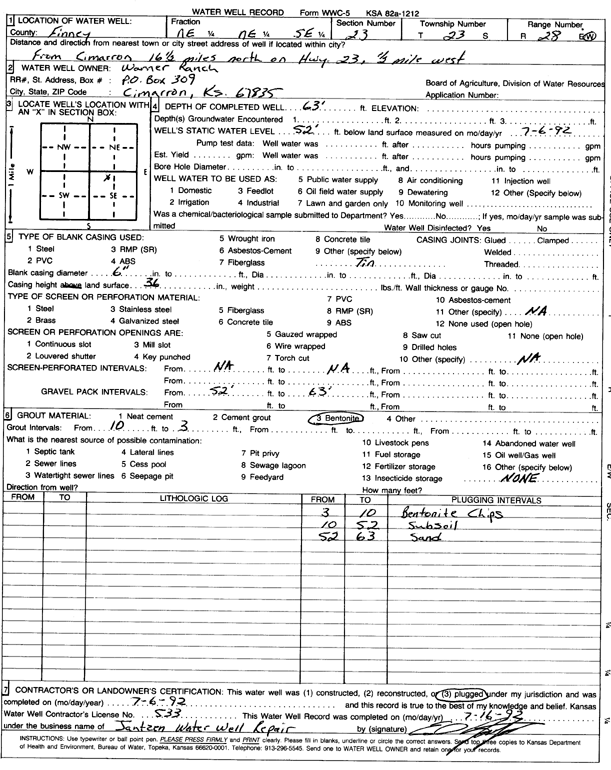
Specific Water Well Detail |
|
|
| Location Info | |||
| Owner: Warner Ranch | Status: Plugged | ||
| Location: T23S, R28W, Sec. 23, NE NE SE | County: Finney | ||
| Directions: from Cimarron: 16.5 mi N on Hwy 23, 0.5 mi W | |||
| Latitude: 38.0364167 | Longitude: -100.3548928 | Datum NAD 27 | |
| Latitude: 38.0364364 | Longitude: -100.3553132 | Datum NAD 83 | |
| Longitude and latitude calculated by Survey from township-range-section-quarter calls. Only good to within the quarter call accuracy. | |||
| View well on interactive map | |||
| General Info | ||
| Well Depth: 63 ft. | Elevation: ft. | |
| Static Water Level: 52 ft. | Est. Yield: gpm. | |
| Comp. Date: 06-Jul-1992 | Well Use: (unstated)/abandoned | |
| DWR Applic. #: | Other ID: | |
| Driller Info | ||
| Driller: Jantzen Water Well | License #: 533 | |
| Scanned Form | View scan |
| Casing Info | ||
|
Casing Type: PVC
Diam: 6 in. Casing height above land surface: in | ||
| Grout Info | ||
| Grout used: Bentonite | From: 3 to 10 ft
From: 0 to 0 ft From: 0 to 0 ft | |
| Source of Possible Contamination | ||
| Source: OTHER | ||
| Direction from well: | Distance: 0 ft | |