|
|
|
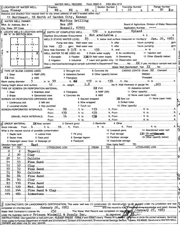
Specific Water Well Detail |
|
|
| Location Info | |||
| Owner: Murfin Drilling Co. | Status: Constructed | ||
| Location: T23S, R30W, Sec. 6, NE NE SE | County: Finney | ||
| Directions: from Garden City, 11 mi NE and 1.5 mi N | |||
| Latitude: 38.081339 | Longitude: -100.6469422 | Datum NAD 27 | |
| Latitude: 38.0813598 | Longitude: -100.6473717 | Datum NAD 83 | |
| Longitude and latitude calculated by Survey from township-range-section-quarter calls. Only good to within the quarter call accuracy. | |||
| View well on interactive map | |||
| General Info | ||
| Well Depth: 159 ft. | Elevation: ft. | |
| Static Water Level: 85 ft. | Est. Yield: 25 gpm. | |
| Comp. Date: 26-Jan-1983 | Well Use: Oil Field Water Supply | |
| DWR Applic. #: | Other ID: | |
| Driller Info | ||
| Driller: Cornie Friesen Windmill and Supply Co. | License #: 252 | |
| Scanned Form | View scan |
|
Chemical Sample Submitted?: No
Water Well disinfected?: | ||
| Ground water encountered: 0 ft. , 0 ft. , 0 ft. | ||
| Pump test data: Well water was 0 ft after 0 hours pumping 0 gpm | ||
| Casing Info | ||
| Casing Type:
Casing Joints: |
Diam: 0 in. to 0 ft
Diam: 0 in. to 0 ft Diam: 0 in. to 0 ft | |
| Casing height above land surface: in
Casing Weight: lbs/ft Wall thickness or gauge no.: | ||
| Screen and Perforation Info | ||
| Screen Type: | Screen Openings: | |
| Screen-perforated intervals | From: 99 ft to 119 ft
From: 139 ft to 159 ft From: 0 ft to 0 ft | |
| Gravel pack intervals | From: ft to ft | |
| Grout Info | ||
| Grout used: | From: 0 to 0 ft
From: 0 to 0 ft From: 0 to 0 ft | |
| Source of Possible Contamination | ||
| Source: | ||
| Direction from well: | Distance: 0 ft | |
| Lithologic Log
(Log data entered by KGS.) | ||
| From: 0 ft. to 2 ft. | topsoil | |
| From: 2 ft. to 20 ft. | clay | |
| From: 20 ft. to 51 ft. | caliche | |
| From: 51 ft. to 53 ft. | fine sand | |
| From: 53 ft. to 57 ft. | clay | |
| From: 57 ft. to 72 ft. | fine sand | |
| From: 72 ft. to 80 ft. | caliche | |
| From: 80 ft. to 84 ft. | fine sand | |
| From: 84 ft. to 93 ft. | clay | |
| From: 93 ft. to 110 ft. | fine sand | |
| From: 110 ft. to 120 ft. | medium sand | |
| From: 120 ft. to 144 ft. | fine sand and clay | |
| From: 144 ft. to 160 ft. | limestone | |