|
|
|
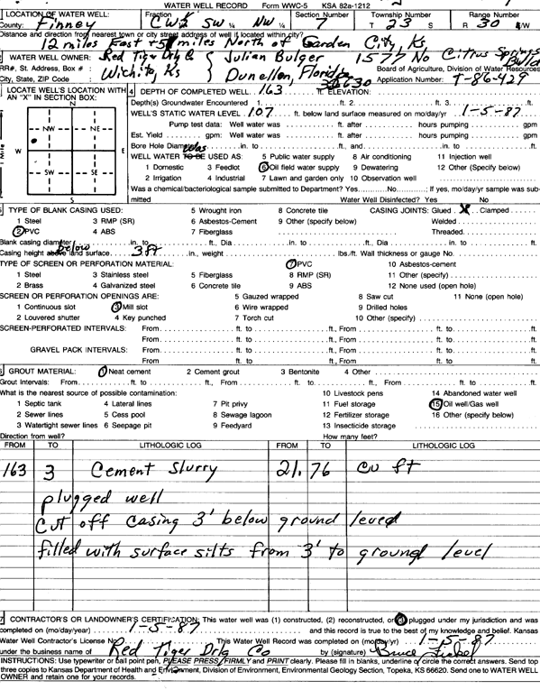
Specific Water Well Detail |
|
|
| Location Info | |||
| Owner: Red Tiger Drilling/Bulger, Julianne | Status: Plugged | ||
| Location: T23S, R30W, Sec. 7, C W2 SW NW | County: Finney | ||
| Directions: from Garden City, 12 mi E and 5 mi N | |||
| Latitude: 38.0696269 | Longitude: -100.6625826 | Datum NAD 27 | |
| Latitude: 38.0696478 | Longitude: -100.6630128 | Datum NAD 83 | |
| Longitude and latitude calculated by Survey from township-range-section-quarter calls. Only good to within the quarter call accuracy. | |||
| View well on interactive map | |||
| General Info | ||
| Well Depth: 163 ft. | Elevation: ft. | |
| Static Water Level: 107 ft. | Est. Yield: gpm. | |
| Comp. Date: 05-Jan-1987 | Well Use: Oil Field Water Supply | |
| DWR Applic. #: T86-429 | Other ID: | |
| Driller Info | ||
| Driller: Red Tiger Drilling Co. | License #: | |
| Scanned Form | View scan |
| Casing Info | ||
|
Casing Type: PVC
Diam: 0 in. Casing height above land surface: in | ||
| Grout Info | ||
| Grout used: Neat cement | From: 0 to 0 ft
From: 0 to 0 ft From: 0 to 0 ft | |
| Source of Possible Contamination | ||
| Source: Oil well/gas well | ||
| Direction from well: | Distance: 0 ft | |