|
|
|
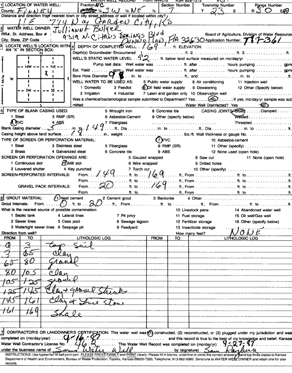
Specific Water Well Detail |
|
|
| Location Info | |||
| Owner: Bulger, Julianne | Status: Constructed | ||
| Location: T23S, R30W, Sec. 7, NC SW NE | County: Finney | ||
| Directions: from Garden City, 11 mi E and 7.25 mi N | |||
| Latitude: 38.0704943 | Longitude: -100.6525465 | Datum NAD 27 | |
| Latitude: 38.0705152 | Longitude: -100.6529764 | Datum NAD 83 | |
| Longitude and latitude calculated by Survey from township-range-section-quarter calls. Only good to within the quarter call accuracy. | |||
| View well on interactive map | |||
| General Info | ||
| Well Depth: 169 ft. | Elevation: ft. | |
| Static Water Level: 92 ft. | Est. Yield: gpm. | |
| Comp. Date: 16-Sep-1987 | Well Use: Oil Field Water Supply | |
| DWR Applic. #: T87-361 | Other ID: | |
| Driller Info | ||
| Driller: Sam's Water Well Service | License #: 462 | |
| Scanned Form | View scan |
|
Chemical Sample Submitted?: No
Water Well disinfected?: | ||
| Ground water encountered: 0 ft. , 0 ft. , 0 ft. | ||
| Pump test data: Well water was 0 ft after 0 hours pumping 0 gpm | ||
| Casing Info | ||
| Casing Type: PVC
Casing Joints: |
Diam: 5 in. to 149 ft
Diam: 0 in. to 0 ft Diam: 0 in. to 0 ft | |
| Casing height above land surface: in
Casing Weight: lbs/ft Wall thickness or gauge no.: | ||
| Screen and Perforation Info | ||
| Screen Type: PVC | Screen Openings: Mill slot | |
| Screen-perforated intervals | From: 149 ft to 169 ft
From: 0 ft to 0 ft From: 0 ft to 0 ft | |
| Gravel pack intervals | From: ft to ft | |
| Grout Info | ||
| Grout used: Neat cement | From: 0 to 20 ft
From: 0 to 0 ft From: 0 to 0 ft | |
| Source of Possible Contamination | ||
| Source: OTHER | ||
| Direction from well: | Distance: 0 ft | |
| Lithologic Log
(Log data entered by KGS.) | ||
| From: 0 ft. to 3 ft. | top soil | |
| From: 3 ft. to 65 ft. | clay | |
| From: 65 ft. to 80 ft. | gravel | |
| From: 80 ft. to 105 ft. | clay | |
| From: 105 ft. to 125 ft. | gravel | |
| From: 125 ft. to 145 ft. | clay and gravel streaks | |
| From: 145 ft. to 161 ft. | clay and lime stone | |
| From: 161 ft. to 169 ft. | shale | |