|
|
|
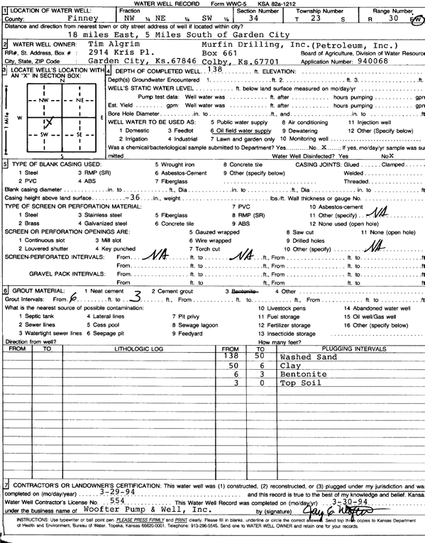
Specific Water Well Detail |
|
|
| Location Info | |||
| Owner: Algrim, Tim | Status: Plugged | ||
| Location: T23S, R30W, Sec. 34, NW NE SW | County: Finney | ||
| Directions: from Garden City, 18 mi E and 5 mi S | |||
| Latitude: 38.0083245 | Longitude: -100.6035573 | Datum NAD 27 | |
| Latitude: 38.0083454 | Longitude: -100.6039863 | Datum NAD 83 | |
| Longitude and latitude calculated by Survey from township-range-section-quarter calls. Only good to within the quarter call accuracy. | |||
| View well on interactive map | |||
| General Info | ||
| Well Depth: 138 ft. | Elevation: ft. | |
| Static Water Level: ft. | Est. Yield: gpm. | |
| Comp. Date: 29-Mar-1994 | Well Use: Oil Field Water Supply | |
| DWR Applic. #: 940068 | Other ID: | |
| Links | |
| No Wizard information available. | |
| View info from WIMAS Water Right Data base... | |
| Driller Info | ||
| Driller: Woofter Pump & Well, Inc. | License #: 554 | |
| Scanned Form | View scan |
| Casing Info | ||
|
Casing Type:
Diam: 0 in. Casing height above land surface: in | ||
| Grout Info | ||
| Grout used: Bentonite | From: 3 to 6 ft
From: 0 to 0 ft From: 0 to 0 ft | |
| Source of Possible Contamination | ||
| Source: OTHER | ||
| Direction from well: | Distance: 0 ft | |