|
|
|
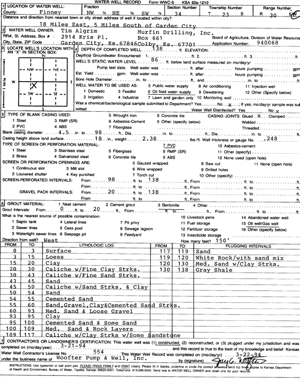
Specific Water Well Detail |
|
|
| Location Info | |||
| Owner: Algrim, Tim | Status: Constructed | ||
| Location: T23S, R30W, Sec. 34, NW NE SW | County: Finney | ||
| Directions: from Garden City, 18 mi E and 5 mi S | |||
| Latitude: 38.0083245 | Longitude: -100.6035573 | Datum NAD 27 | |
| Latitude: 38.0083454 | Longitude: -100.6039863 | Datum NAD 83 | |
| Longitude and latitude calculated by Survey from township-range-section-quarter calls. Only good to within the quarter call accuracy. | |||
| View well on interactive map | |||
| General Info | ||
| Well Depth: 138 ft. | Elevation: ft. | |
| Static Water Level: 86 ft. | Est. Yield: gpm. | |
| Comp. Date: 21-Mar-1994 | Well Use: Oil Field Water Supply | |
| DWR Applic. #: 940068 | Other ID: | |
| Links | |
| No Wizard information available. | |
| View info from WIMAS Water Right Data base... | |
| Driller Info | ||
| Driller: Woofter Pump & Well, Inc. | License #: 554 | |
| Scanned Form | View scan |
|
Chemical Sample Submitted?: No
Water Well disinfected?: | ||
| Ground water encountered: 0 ft. , 0 ft. , 0 ft. | ||
| Pump test data: Well water was 0 ft after 0 hours pumping 0 gpm | ||
| Casing Info | ||
| Casing Type: PVC
Casing Joints: |
Diam: 4 in. to 98 ft
Diam: 0 in. to 0 ft Diam: 0 in. to 0 ft | |
| Casing height above land surface: in
Casing Weight: lbs/ft Wall thickness or gauge no.: | ||
| Screen and Perforation Info | ||
| Screen Type: PVC | Screen Openings: OTHER | |
| Screen-perforated intervals | From: 98 ft to 138 ft
From: 0 ft to 0 ft From: 0 ft to 0 ft | |
| Gravel pack intervals | From: ft to ft | |
| Grout Info | ||
| Grout used: Bentonite | From: 0 to 20 ft
From: 0 to 0 ft From: 0 to 0 ft | |
| Source of Possible Contamination | ||
| Source: Oil well/gas well | ||
| Direction from well: | Distance: 0 ft | |
| Lithologic Log
(Log data entered by KGS.) | ||
| From: 0 ft. to 3 ft. | surface | |
| From: 3 ft. to 15 ft. | loess | |
| From: 15 ft. to 20 ft. | clay | |
| From: 20 ft. to 30 ft. | caliche with fine clay streaks | |
| From: 30 ft. to 43 ft. | caliche with fine sand streaks | |
| From: 43 ft. to 45 ft. | sand | |
| From: 45 ft. to 50 ft. | caliche with sand streaks and clay | |
| From: 50 ft. to 54 ft. | sand | |
| From: 54 ft. to 55 ft. | cemented sand | |
| From: 55 ft. to 60 ft. | sand, gravel, clay and cemented sand streaks | |
| From: 60 ft. to 93 ft. | medium sand and loose gravel | |
| From: 93 ft. to 95 ft. | clay | |
| From: 95 ft. to 100 ft. | cemented sand and some sand | |
| From: 100 ft. to 109 ft. | medium sand and rock layers | |
| From: 109 ft. to 117 ft. | caliche with clay streaks with some sandstone | |
| From: 117 ft. to 119 ft. | sand | |
| From: 119 ft. to 120 ft. | white rock with sand mix | |
| From: 120 ft. to 130 ft. | medium sand with clay streaks | |
| From: 130 ft. to 138 ft. | gray shale | |