|
|
|
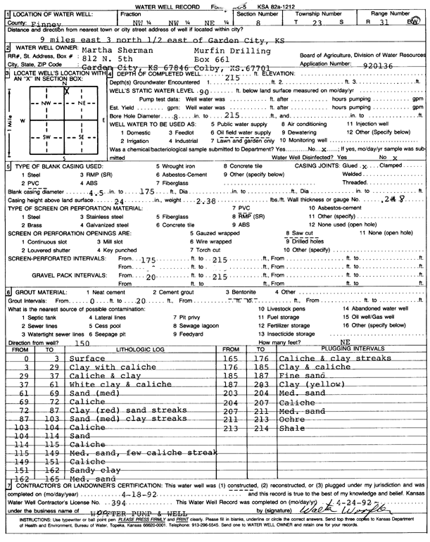
Specific Water Well Detail |
|
|
| Location Info | |||
| Owner: Murfin Drilling/Sherman, Martha | Status: Constructed | ||
| Location: T23S, R31W, Sec. 8, NW NW NE | County: Finney | ||
| Directions: from Garden City, 9 mi E, 3 mi N, and 0.5 mi E | |||
| Latitude: 38.0746722 | Longitude: -100.7451947 | Datum NAD 27 | |
| Latitude: 38.0746936 | Longitude: -100.7456277 | Datum NAD 83 | |
| Longitude and latitude calculated by Survey from township-range-section-quarter calls. Only good to within the quarter call accuracy. | |||
| View well on interactive map | |||
| General Info | ||
| Well Depth: 215 ft. | Elevation: ft. | |
| Static Water Level: 90 ft. | Est. Yield: gpm. | |
| Comp. Date: 18-Apr-1992 | Well Use: Oil Field Water Supply | |
| DWR Applic. #: 920136 | Other ID: | |
| Links | |
| No Wizard information available. | |
| View info from WIMAS Water Right Data base... | |
| Driller Info | ||
| Driller: Walter Woofter Pump & Well | License #: 394 | |
| Scanned Form | View scan |
|
Chemical Sample Submitted?: No
Water Well disinfected?: | ||
| Ground water encountered: 0 ft. , 0 ft. , 0 ft. | ||
| Pump test data: Well water was 0 ft after 0 hours pumping 0 gpm | ||
| Casing Info | ||
| Casing Type: PVC
Casing Joints: |
Diam: 4 in. to 175 ft
Diam: 0 in. to 0 ft Diam: 0 in. to 0 ft | |
| Casing height above land surface: in
Casing Weight: lbs/ft Wall thickness or gauge no.: | ||
| Screen and Perforation Info | ||
| Screen Type: PVC | Screen Openings: Saw cut | |
| Screen-perforated intervals | From: 175 ft to 215 ft
From: 0 ft to 0 ft From: 0 ft to 0 ft | |
| Gravel pack intervals | From: ft to ft | |
| Grout Info | ||
| Grout used: Bentonite | From: 0 to 20 ft
From: 0 to 0 ft From: 0 to 0 ft | |
| Source of Possible Contamination | ||
| Source: OTHER | ||
| Direction from well: | Distance: 0 ft | |
| Lithologic Log
(Log data entered by KGS.) | ||
| From: 0 ft. to 3 ft. | surface | |
| From: 3 ft. to 29 ft. | clay with caliche | |
| From: 29 ft. to 37 ft. | caliche and clay | |
| From: 37 ft. to 61 ft. | white clay and caliche | |
| From: 61 ft. to 69 ft. | sand (med) | |
| From: 69 ft. to 72 ft. | caliche | |
| From: 72 ft. to 87 ft. | clay (red) sand streaks | |
| From: 87 ft. to 103 ft. | sand (med) clay streaks | |
| From: 103 ft. to 104 ft. | caliche | |
| From: 104 ft. to 114 ft. | sand | |
| From: 114 ft. to 115 ft. | caliche | |
| From: 115 ft. to 149 ft. | medium sand, few caliche streak | |
| From: 149 ft. to 151 ft. | caliche | |
| From: 151 ft. to 162 ft. | sandy clay | |
| From: 162 ft. to 165 ft. | medium sand | |
| From: 165 ft. to 176 ft. | caliche and clay streaks | |
| From: 176 ft. to 185 ft. | clay and caliche | |
| From: 185 ft. to 187 ft. | fine sand | |
| From: 187 ft. to 203 ft. | clay (yellow) | |
| From: 203 ft. to 204 ft. | medium sand | |
| From: 204 ft. to 207 ft. | caliche | |
| From: 207 ft. to 211 ft. | medium sand | |
| From: 211 ft. to 213 ft. | ochre | |
| From: 213 ft. to 214 ft. | shale | |