|
|
|
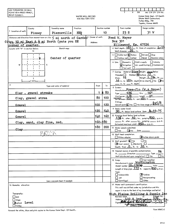
Specific Water Well Detail |
|
|
| Location Info | |||
| Owner: Meyer, Fred W. | Status: Constructed | ||
| Location: T23S, R31W, Sec. 10, NE | County: Finney | ||
| Directions: from Garden City, 5 mi N, 10 mi E, and 0.5 mi N | |||
| Latitude: 38.0717868 | Longitude: -100.7048761 | Datum NAD 27 | |
| Latitude: 38.071808 | Longitude: -100.7053077 | Datum NAD 83 | |
| Longitude and latitude calculated by Survey from township-range-section-quarter calls. Only good to within the quarter call accuracy. | |||
| View well on interactive map | |||
| General Info | ||
| Well Depth: 181 ft. | Elevation: ft. | |
| Static Water Level: 90 ft. | Est. Yield: 950 gpm. | |
| Comp. Date: 19-Apr-1975 | Well Use: Irrigation | |
| DWR Applic. #: | Other ID: | |
| Links | |
| View info from Wizard Water Level Data base... | |
| View info from WIMAS Water Right Data base... | |
| Driller Info | ||
| Driller: High Plains Drilling & Supply | License #: 136 | |
| Scanned Form | View scan |
|
Chemical Sample Submitted?: No
Water Well disinfected?: | ||
| Ground water encountered: 0 ft. , 0 ft. , 0 ft. | ||
| Pump test data: Well water was 0 ft after 0 hours pumping 0 gpm | ||
| Casing Info | ||
| Casing Type:
Casing Joints: |
Diam: 0 in. to 0 ft
Diam: 0 in. to 0 ft Diam: 0 in. to 0 ft | |
| Casing height above land surface: in
Casing Weight: lbs/ft Wall thickness or gauge no.: | ||
| Screen and Perforation Info | ||
| Screen Type: | Screen Openings: | |
| Screen-perforated intervals | From: 101 ft to 181 ft
From: 0 ft to 0 ft From: 0 ft to 0 ft | |
| Gravel pack intervals | From: ft to ft | |
| Grout Info | ||
| Grout used: | From: 0 to 0 ft
From: 0 to 0 ft From: 0 to 0 ft | |
| Source of Possible Contamination | ||
| Source: | ||
| Direction from well: | Distance: 0 ft | |
| Lithologic Log
(Log data entered by KGS.) | ||
| From: 0 ft. to 80 ft. | clay, gravel streaks | |
| From: 80 ft. to 100 ft. | clay, gravel streak | |
| From: 100 ft. to 120 ft. | gravel | |
| From: 120 ft. to 140 ft. | gravel | |
| From: 140 ft. to 160 ft. | gravel | |
| From: 160 ft. to 180 ft. | clay, sand, clay fine, med. | |
| From: 180 ft. to 200 ft. | clay | |