|
|
|
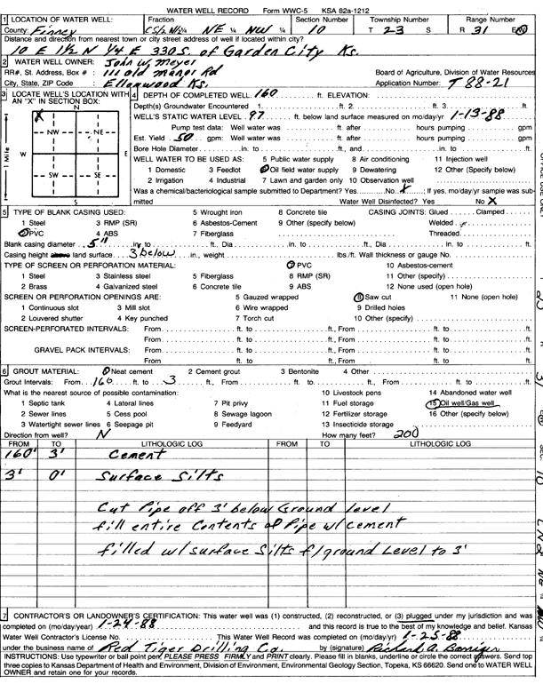
Specific Water Well Detail |
|
|
| Location Info | |||
| Owner: Meyer, John W. | Status: Plugged | ||
| Location: T23S, R31W, Sec. 10, N2 NE NW | County: Finney | ||
| Directions: from Garden City, 10 mi E, 1.5 mi N, 0.25 mi E, and 330 feet S | |||
| Latitude: 38.0745829 | Longitude: -100.7117826 | Datum NAD 27 | |
| Latitude: 38.0746042 | Longitude: -100.7122143 | Datum NAD 83 | |
| Longitude and latitude calculated by Survey from township-range-section-quarter calls. Only good to within the quarter call accuracy. | |||
| View well on interactive map | |||
| General Info | ||
| Well Depth: 160 ft. | Elevation: ft. | |
| Static Water Level: 97 ft. | Est. Yield: 50 gpm. | |
| Comp. Date: 24-Jan-1988 | Well Use: Oil Field Water Supply | |
| DWR Applic. #: T88-21 | Other ID: | |
| Links | |
| No Wizard information available. | |
| View info from WIMAS Water Right Data base... | |
| Driller Info | ||
| Driller: Red Tiger Drilling Co. | License #: | |
| Scanned Form | View scan |
| Casing Info | ||
|
Casing Type: PVC
Diam: 5 in. Casing height above land surface: in | ||
| Grout Info | ||
| Grout used: Neat cement | From: 160 to 33 ft
From: 0 to 0 ft From: 0 to 0 ft | |
| Source of Possible Contamination | ||
| Source: Oil well/gas well | ||
| Direction from well: | Distance: 0 ft | |