|
|
|
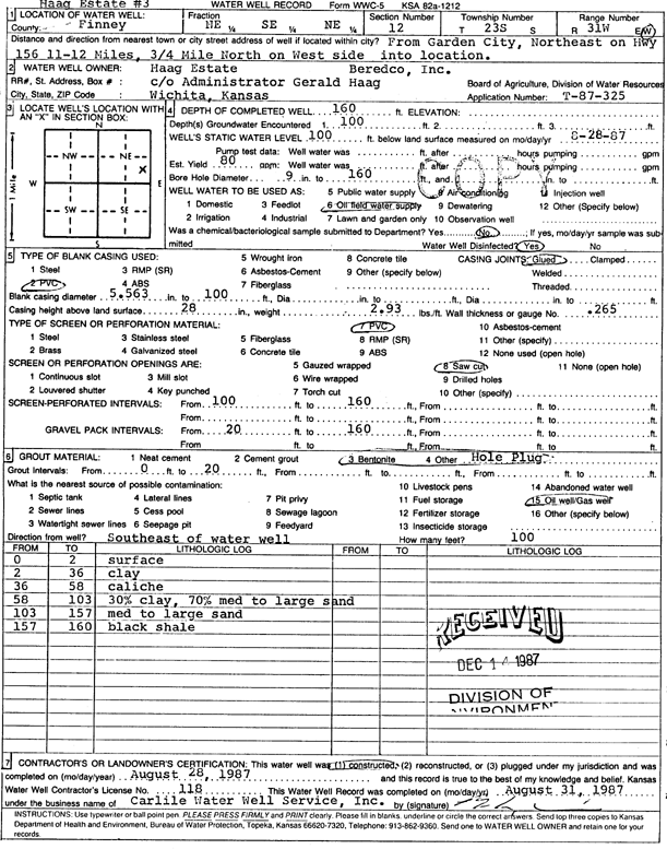
Specific Water Well Detail |
|
|
| Location Info | |||
| Owner: Beredco, Inc./Haag Estate | Status: Constructed | ||
| Location: T23S, R31W, Sec. 12, NE SE NE | County: Finney | ||
| Directions: from Garden City: 11-12 mi NE on Hwy 156, 0.75 mi N, on W side | |||
| Latitude: 38.0705495 | Longitude: -100.6648378 | Datum NAD 27 | |
| Latitude: 38.0705704 | Longitude: -100.6652681 | Datum NAD 83 | |
| Longitude and latitude calculated by Survey from township-range-section-quarter calls. Only good to within the quarter call accuracy. | |||
| View well on interactive map | |||
| General Info | ||
| Well Depth: 160 ft. | Elevation: ft. | |
| Static Water Level: 100 ft. | Est. Yield: 80 gpm. | |
| Comp. Date: 28-Aug-1987 | Well Use: Oil Field Water Supply | |
| DWR Applic. #: T87-325 | Other ID: Haag Estate 3 | |
| Driller Info | ||
| Driller: Bernard E. Carlile Water Well Service, Inc. | License #: 118 | |
| Scanned Form | View scan |
|
Chemical Sample Submitted?: No
Water Well disinfected?: | ||
| Ground water encountered: 100 ft. , 0 ft. , 0 ft. | ||
| Pump test data: Well water was 0 ft after 0 hours pumping 0 gpm | ||
| Casing Info | ||
| Casing Type: PVC
Casing Joints: |
Diam: 5 in. to 100 ft
Diam: 0 in. to 0 ft Diam: 0 in. to 0 ft | |
| Casing height above land surface: in
Casing Weight: lbs/ft Wall thickness or gauge no.: | ||
| Screen and Perforation Info | ||
| Screen Type: PVC | Screen Openings: Saw cut | |
| Screen-perforated intervals | From: 100 ft to 160 ft
From: 0 ft to 0 ft From: 0 ft to 0 ft | |
| Gravel pack intervals | From: ft to ft | |
| Grout Info | ||
| Grout used: Bentonite, | From: 0 to 20 ft
From: 0 to 0 ft From: 0 to 0 ft | |
| Source of Possible Contamination | ||
| Source: Oil well/gas well | ||
| Direction from well: | Distance: 0 ft | |
| Lithologic Log
(Log data entered by KGS.) | ||
| From: 0 ft. to 2 ft. | surface | |
| From: 2 ft. to 36 ft. | clay | |
| From: 36 ft. to 58 ft. | caliche | |
| From: 58 ft. to 103 ft. | clay and medium to large sand (30/70) | |
| From: 103 ft. to 157 ft. | medium to large sand | |
| From: 157 ft. to 160 ft. | black shale | |