|
|
|
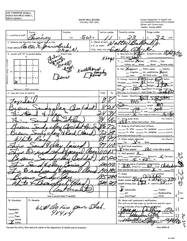
Specific Water Well Detail |
|
|
| Location Info | |||
| Owner: Walter Bullock, Jr. | Status: Constructed | ||
| Location: T23S, R32W, Sec. 11, SW | County: Finney | ||
| Directions: .5 mi E Jennie Barker Rd, 2.25 mi N | |||
| Latitude: 38.0654317 | Longitude: -100.8056678 | Datum NAD 27 | |
| Latitude: 38.0654538 | Longitude: -100.8061032 | Datum NAD 83 | |
| Longitude and latitude calculated by Survey from township-range-section-quarter calls. Only good to within the quarter call accuracy. | |||
| View well on interactive map | |||
| General Info | ||
| Well Depth: 200 ft. | Elevation: ft. | |
| Static Water Level: 133 ft. | Est. Yield: gpm. | |
| Comp. Date: 23-Aug-1976 | Well Use: Domestic, Livestock | |
| DWR Applic. #: | Other ID: | |
| Driller Info | ||
| Driller: Jonagan Water Well Service LLC | License #: 172 | |
| Scanned Form | View scan |
|
Chemical Sample Submitted?: No
Water Well disinfected?: | ||
| Ground water encountered: 0 ft. , 0 ft. , 0 ft. | ||
| Pump test data: Well water was 0 ft after 0 hours pumping 0 gpm | ||
| Casing Info | ||
| Casing Type:
Casing Joints: |
Diam: 0 in. to 0 ft
Diam: 0 in. to 0 ft Diam: 0 in. to 0 ft | |
| Casing height above land surface: in
Casing Weight: lbs/ft Wall thickness or gauge no.: | ||
| Screen and Perforation Info | ||
| Screen Type: | Screen Openings: | |
| Screen-perforated intervals | From: 170 ft to 200 ft
From: 0 ft to 0 ft From: 0 ft to 0 ft | |
| Gravel pack intervals | From: ft to ft | |
| Grout Info | ||
| Grout used: | From: 0 to 0 ft
From: 0 to 0 ft From: 0 to 0 ft | |
| Source of Possible Contamination | ||
| Source: | ||
| Direction from well: | Distance: 0 ft | |
| Lithologic Log
(Log data entered by KGS.) | ||
| From: 0 ft. to 8 ft. | topsoil | |
| From: 8 ft. to 24 ft. | brown sandy clay (small hard streak) | |
| From: 24 ft. to 34 ft. | fine sand and clay | |
| From: 34 ft. to 46 ft. | fine sand (small streak clay) | |
| From: 46 ft. to 72 ft. | brown sandy clay (small hard streak and fine sand) | |
| From: 72 ft. to 89 ft. | brown sandy clay and rock (hard) | |
| From: 89 ft. to 97 ft. | white rock | |
| From: 97 ft. to 110 ft. | fine sand and clay (mixed) | |
| From: 110 ft. to 115 ft. | fine to medium sand and gravel (loose) | |
| From: 115 ft. to 120 ft. | brown sandy clay (sm hard streak) | |
| From: 120 ft. to 140 ft. | fine sand and clay (mixed) | |
| From: 140 ft. to 195 ft. | fine to medium sand and gravel (loose) | |
| From: 195 ft. to 200 ft. | brown sandy clay | |
| From: 200 ft. to 207 ft. | white and brown rock (hard) (lost circulation) | |