|
|
|
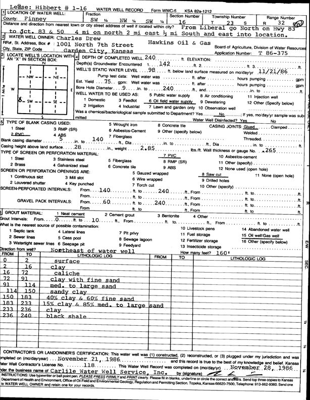
Specific Water Well Detail |
|
|
| Location Info | |||
| Owner: Drew, Charles | Status: Constructed | ||
| Location: T23S, R32W, Sec. 16, SW NW SW | County: Finney | ||
| Directions: from Liberal, N on Hwy 83 to Jct 83 and 50, 4 mi N, 2 mi E, and 0.5 mi S and E | |||
| Latitude: 38.0519088 | Longitude: -100.8459163 | Datum NAD 27 | |
| Latitude: 38.0519313 | Longitude: -100.8463535 | Datum NAD 83 | |
| Longitude and latitude calculated by Survey from township-range-section-quarter calls. Only good to within the quarter call accuracy. | |||
| View well on interactive map | |||
| General Info | ||
| Well Depth: 240 ft. | Elevation: ft. | |
| Static Water Level: 98 ft. | Est. Yield: 75 gpm. | |
| Comp. Date: 21-Nov-1986 | Well Use: Oil Field Water Supply | |
| DWR Applic. #: T86-375 | Other ID: Hibbert 1-16 | |
| Driller Info | ||
| Driller: Bernard E. Carlile Water Well Service, Inc. | License #: 118 | |
| Scanned Form | View scan |
|
Chemical Sample Submitted?: No
Water Well disinfected?: | ||
| Ground water encountered: 0 ft. , 142 ft. , 0 ft. | ||
| Pump test data: Well water was 0 ft after 0 hours pumping 0 gpm | ||
| Casing Info | ||
| Casing Type: PVC
Casing Joints: |
Diam: 5 in. to 140 ft
Diam: 0 in. to 0 ft Diam: 0 in. to 0 ft | |
| Casing height above land surface: in
Casing Weight: lbs/ft Wall thickness or gauge no.: | ||
| Screen and Perforation Info | ||
| Screen Type: PVC | Screen Openings: Saw cut | |
| Screen-perforated intervals | From: 140 ft to 240 ft
From: 0 ft to 0 ft From: 0 ft to 0 ft | |
| Gravel pack intervals | From: ft to ft | |
| Grout Info | ||
| Grout used: Neat cement | From: 0 to 10 ft
From: 0 to 0 ft From: 0 to 0 ft | |
| Source of Possible Contamination | ||
| Source: Oil well/gas well | ||
| Direction from well: | Distance: 0 ft | |
| Lithologic Log
(Log data entered by KGS.) | ||
| From: 0 ft. to 2 ft. | surface | |
| From: 2 ft. to 16 ft. | clay | |
| From: 16 ft. to 72 ft. | caliche | |
| From: 72 ft. to 91 ft. | clay with fine sand | |
| From: 91 ft. to 114 ft. | med. to large sand | |
| From: 114 ft. to 150 ft. | sandy clay | |
| From: 150 ft. to 183 ft. | 40% clay and 60% fine sand | |
| From: 183 ft. to 233 ft. | 15% clay and 85% med. to large sand | |
| From: 233 ft. to 236 ft. | clay | |
| From: 236 ft. to 240 ft. | black shale | |