|
|
|
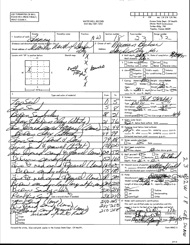
Specific Water Well Detail |
|
|
| Location Info | |||
| Owner: Becker, Norman | Status: Constructed | ||
| Location: T23S, R32W, Sec. 18, NW | County: Finney | ||
| Directions: from Garden City, 6 mi N | |||
| Latitude: 38.0583981 | Longitude: -100.8786077 | Datum NAD 27 | |
| Latitude: 38.0584209 | Longitude: -100.8790459 | Datum NAD 83 | |
| Longitude and latitude calculated by Survey from township-range-section-quarter calls. Only good to within the quarter call accuracy. | |||
| View well on interactive map | |||
| General Info | ||
| Well Depth: 265 ft. | Elevation: ft. | |
| Static Water Level: 42 ft. | Est. Yield: gpm. | |
| Comp. Date: 24-Aug-1975 | Well Use: Domestic | |
| DWR Applic. #: | Other ID: | |
| Driller Info | ||
| Driller: Jonagan Drilling | License #: 172 | |
| Scanned Form | View scan |
|
Chemical Sample Submitted?: No
Water Well disinfected?: | ||
| Ground water encountered: 0 ft. , 0 ft. , 0 ft. | ||
| Pump test data: Well water was 0 ft after 0 hours pumping 0 gpm | ||
| Casing Info | ||
| Casing Type:
Casing Joints: |
Diam: 0 in. to 0 ft
Diam: 0 in. to 0 ft Diam: 0 in. to 0 ft | |
| Casing height above land surface: in
Casing Weight: lbs/ft Wall thickness or gauge no.: | ||
| Screen and Perforation Info | ||
| Screen Type: | Screen Openings: | |
| Screen-perforated intervals | From: 245 ft to 265 ft
From: 0 ft to 0 ft From: 0 ft to 0 ft | |
| Gravel pack intervals | From: ft to ft | |
| Grout Info | ||
| Grout used: | From: 0 to 0 ft
From: 0 to 0 ft From: 0 to 0 ft | |
| Source of Possible Contamination | ||
| Source: | ||
| Direction from well: | Distance: 0 ft | |
| Lithologic Log
(Log data entered by KGS.) | ||
| From: 0 ft. to 5 ft. | topsoil | |
| From: 5 ft. to 8 ft. | fine sand | |
| From: 8 ft. to 21 ft. | brown sandy clay | |
| From: 21 ft. to 36 ft. | gray and brown clay (sticky) | |
| From: 36 ft. to 44 ft. | fine to medium sand and gravel (loose) | |
| From: 44 ft. to 79 ft. | brown clay (sticky) | |
| From: 79 ft. to 108 ft. | fine sand, rock and clay | |
| From: 108 ft. to 120 ft. | fine sand and gravel (clay st) | |
| From: 120 ft. to 152 ft. | fine to medium sand and gravel (loose) | |
| From: 152 ft. to 160 ft. | brown sandy clay | |
| From: 160 ft. to 175 ft. | fine to medium sand and gravel (loose) | |
| From: 175 ft. to 180 ft. | brown sandy clay | |
| From: 180 ft. to 200 ft. | fine to medium sand and gravel (loose) | |
| From: 200 ft. to 220 ft. | brown sandy clay (large st fine sand) | |
| From: 220 ft. to 236 ft. | brown sandy clay | |
| From: 236 ft. to 240 ft. | real fine sand | |
| From: 240 ft. to 245 ft. | fine sand (loose) | |
| From: 245 ft. to 250 ft. | fine and medium sand (loose) | |
| From: 250 ft. to 258 ft. | fine to medium sand and gravel (loose) mixed with white rock | |