|
|
|
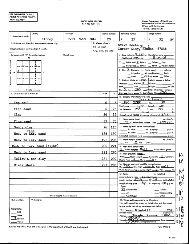
Specific Water Well Detail |
|
|
| Location Info | |||
| Owner: Koehn, Steve | Status: Constructed | ||
| Location: T23S, R32W, Sec. 20, NW SW SW | County: Finney | ||
| Directions: | |||
| Latitude: 38.0356229 | Longitude: -100.8643498 | Datum NAD 27 | |
| Latitude: 38.0356457 | Longitude: -100.864788 | Datum NAD 83 | |
| Longitude and latitude calculated by Survey from township-range-section-quarter calls. Only good to within the quarter call accuracy. | |||
| View well on interactive map | |||
| General Info | ||
| Well Depth: 295 ft. | Elevation: ft. | |
| Static Water Level: 79 ft. | Est. Yield: gpm. | |
| Comp. Date: 03-Aug-1976 | Well Use: Domestic | |
| DWR Applic. #: | Other ID: | |
| Driller Info | ||
| Driller: Friesen Windmill | License #: 252 | |
| Scanned Form | View scan |
|
Chemical Sample Submitted?: No
Water Well disinfected?: | ||
| Ground water encountered: 0 ft. , 0 ft. , 0 ft. | ||
| Pump test data: Well water was 0 ft after 0 hours pumping 0 gpm | ||
| Casing Info | ||
| Casing Type:
Casing Joints: |
Diam: 0 in. to 0 ft
Diam: 0 in. to 0 ft Diam: 0 in. to 0 ft | |
| Casing height above land surface: in
Casing Weight: lbs/ft Wall thickness or gauge no.: | ||
| Screen and Perforation Info | ||
| Screen Type: | Screen Openings: | |
| Screen-perforated intervals | From: 255 ft to 295 ft
From: 0 ft to 0 ft From: 0 ft to 0 ft | |
| Gravel pack intervals | From: ft to ft | |
| Grout Info | ||
| Grout used: | From: 0 to 0 ft
From: 0 to 0 ft From: 0 to 0 ft | |
| Source of Possible Contamination | ||
| Source: | ||
| Direction from well: | Distance: 0 ft | |
| Lithologic Log
(Log data entered by KGS.) | ||
| From: 0 ft. to 5 ft. | top soil | |
| From: 5 ft. to 25 ft. | fine sand | |
| From: 25 ft. to 32 ft. | clay | |
| From: 32 ft. to 75 ft. | fine sand | |
| From: 75 ft. to 125 ft. | sandy clay | |
| From: 125 ft. to 190 ft. | medium to fine sand | |
| From: 190 ft. to 205 ft. | medium to large sand | |
| From: 205 ft. to 221 ft. | medium to large sand (tight) | |
| From: 221 ft. to 280 ft. | medium to large sand | |
| From: 280 ft. to 292 ft. | yellow and tan clay | |
| From: 292 ft. to 295 ft. | black shale | |