|
|
|
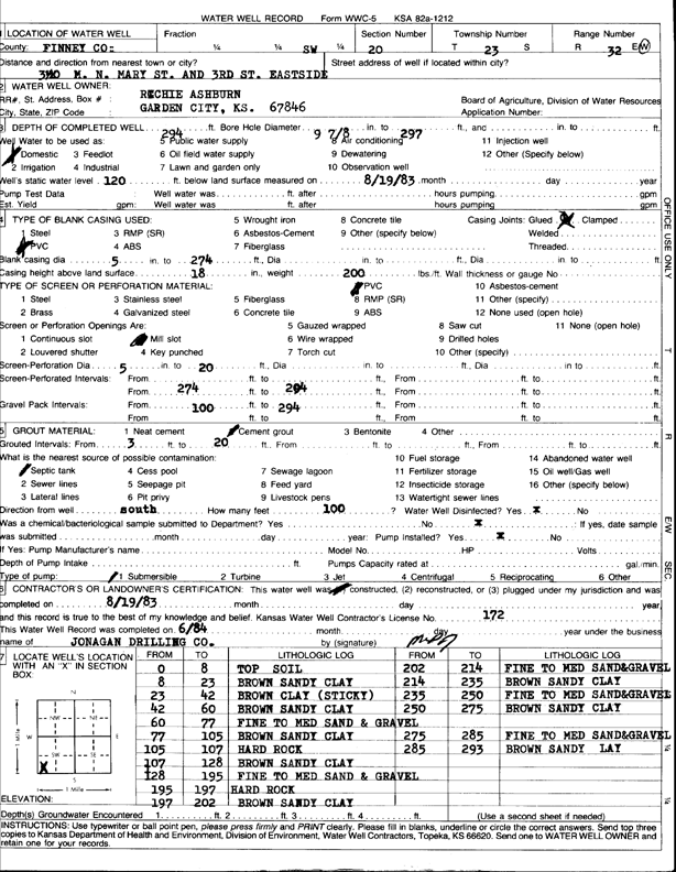
Specific Water Well Detail |
|
|
| Location Info | |||
| Owner: Ashburn, Richie | Status: Constructed | ||
| Location: T23S, R32W, Sec. 20, SW | County: Finney | ||
| Directions: from N Mary St. and 3rd St, 3 mi N, E side | |||
| Latitude: 38.0365192 | Longitude: -100.8609094 | Datum NAD 27 | |
| Latitude: 38.036542 | Longitude: -100.8613474 | Datum NAD 83 | |
| Longitude and latitude calculated by Survey from township-range-section-quarter calls. Only good to within the quarter call accuracy. | |||
| View well on interactive map | |||
| General Info | ||
| Well Depth: 294 ft. | Elevation: ft. | |
| Static Water Level: 120 ft. | Est. Yield: gpm. | |
| Comp. Date: 19-Aug-1983 | Well Use: Domestic | |
| DWR Applic. #: | Other ID: | |
| Driller Info | ||
| Driller: Jonagan Drilling | License #: 172 | |
| Scanned Form | View scan |
|
Chemical Sample Submitted?: No
Water Well disinfected?: | ||
| Ground water encountered: 0 ft. , 0 ft. , 0 ft. | ||
| Pump test data: Well water was 0 ft after 0 hours pumping 0 gpm | ||
| Casing Info | ||
| Casing Type: PVC
Casing Joints: |
Diam: 5 in. to 274 ft
Diam: 0 in. to 0 ft Diam: 0 in. to 0 ft | |
| Casing height above land surface: in
Casing Weight: lbs/ft Wall thickness or gauge no.: | ||
| Screen and Perforation Info | ||
| Screen Type: PVC | Screen Openings: Mill slot | |
| Screen-perforated intervals | From: 0 ft to 0 ft
From: 0 ft to 0 ft From: 274 ft to 294 ft | |
| Gravel pack intervals | From: ft to ft | |
| Grout Info | ||
| Grout used: Cement grout | From: 3 to 20 ft
From: 0 to 0 ft From: 0 to 0 ft | |
| Source of Possible Contamination | ||
| Source: Septic Tank | ||
| Direction from well: | Distance: 0 ft | |
| Lithologic Log
(Log data entered by KGS.) | ||
| From: 0 ft. to 8 ft. | top soil | |
| From: 8 ft. to 23 ft. | brown sandy clay | |
| From: 23 ft. to 42 ft. | brown clay (sticky) | |
| From: 42 ft. to 60 ft. | brown sandy clay | |
| From: 60 ft. to 77 ft. | fine to medium sand and gravel | |
| From: 77 ft. to 105 ft. | brown sandy clay | |
| From: 105 ft. to 107 ft. | hard rock | |
| From: 107 ft. to 128 ft. | brown sandy clay | |
| From: 128 ft. to 195 ft. | fine to medium sand and gravel | |
| From: 195 ft. to 197 ft. | hard rock | |
| From: 197 ft. to 202 ft. | brown sandy clay | |
| From: 202 ft. to 214 ft. | fine to medium sand and gravel | |
| From: 214 ft. to 235 ft. | brown sandy clay | |
| From: 235 ft. to 250 ft. | fine to medium sand and gravel | |
| From: 250 ft. to 275 ft. | brown sandy clay | |
| From: 275 ft. to 285 ft. | fine to medium sand and gravel | |
| From: 285 ft. to 293 ft. | brown sandy clay | |