|
|
|
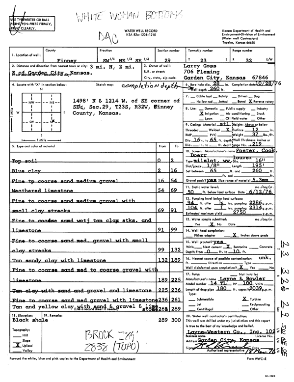
Specific Water Well Detail |
|
|
| Location Info | |||
| Owner: Goss, Larry | Status: Constructed | ||
| Location: T23S, R32W, Sec. 29, SW NE SE | County: Finney | ||
| Directions: from Garden City, 3 mi N, 2 mi E | |||
| Latitude: 38.0228748 | Longitude: -100.8506462 | Datum NAD 27 | |
| Latitude: 38.0228974 | Longitude: -100.8510842 | Datum NAD 83 | |
| Longitude and latitude calculated by Survey from township-range-section-quarter calls. Only good to within the quarter call accuracy. | |||
| View well on interactive map | |||
| General Info | ||
| Well Depth: 260 ft. | Elevation: ft. | |
| Static Water Level: 50 ft. | Est. Yield: 2750 gpm. | |
| Comp. Date: 28-Oct-1976 | Well Use: Irrigation | |
| DWR Applic. #: | Other ID: | |
| Links | |
| View info from Wizard Water Level Data base... | |
| View info from WIMAS Water Right Data base... | |
| Driller Info | ||
| Driller: Layne-Christensen Co. | License #: 102 | |
| Scanned Form | View scan |
|
Chemical Sample Submitted?: No
Water Well disinfected?: | ||
| Ground water encountered: 0 ft. , 0 ft. , 0 ft. | ||
| Pump test data: Well water was 0 ft after 0 hours pumping 0 gpm | ||
| Casing Info | ||
| Casing Type:
Casing Joints: |
Diam: 0 in. to 0 ft
Diam: 0 in. to 0 ft Diam: 0 in. to 0 ft | |
| Casing height above land surface: in
Casing Weight: lbs/ft Wall thickness or gauge no.: | ||
| Screen and Perforation Info | ||
| Screen Type: | Screen Openings: | |
| Screen-perforated intervals | From: 65 ft to 260 ft
From: 0 ft to 0 ft From: 0 ft to 0 ft | |
| Gravel pack intervals | From: ft to ft | |
| Grout Info | ||
| Grout used: | From: 0 to 0 ft
From: 0 to 0 ft From: 0 to 0 ft | |
| Source of Possible Contamination | ||
| Source: | ||
| Direction from well: | Distance: 0 ft | |
| Lithologic Log
(Log data entered by KGS.) | ||
| From: 0 ft. to 2 ft. | top soil | |
| From: 2 ft. to 16 ft. | blue clay | |
| From: 16 ft. to 54 ft. | fine to coarse sand medium gravel | |
| From: 54 ft. to 69 ft. | weathered limestone | |
| From: 69 ft. to 91 ft. | fine to coarse sand medium gravel with small clay streaks | |
| From: 91 ft. to 99 ft. | fine to coarse sand with tan clay streaks and limestone | |
| From: 99 ft. to 132 ft. | fine to coarse sand medium gravel with small clay streaks | |
| From: 132 ft. to 189 ft. | tan sandy clay with limestone | |
| From: 189 ft. to 225 ft. | fine to coarse sand med to coarse gravel with limestone | |
| From: 225 ft. to 236 ft. | tan clay with sand and gravel and limestone | |
| From: 236 ft. to 261 ft. | fine to coarse sand med gravel with limestone | |
| From: 261 ft. to 289 ft. | tan and yellow clay with sand and gravel and limestone | |
| From: 289 ft. to 300 ft. | black shale | |