|
|
|
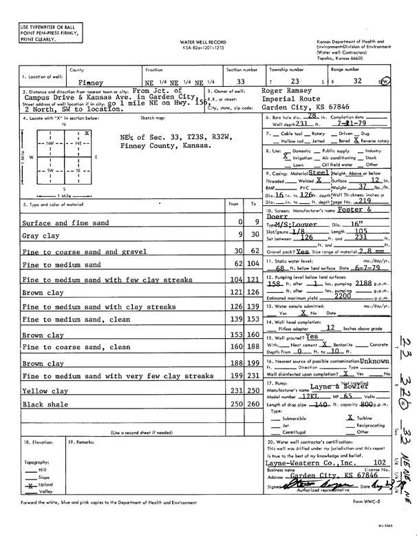
Specific Water Well Detail |
|
|
| Location Info | |||
| Owner: Ramsey, Roger | Status: Constructed | ||
| Location: T23S, R32W, Sec. 33, NE NE NE | County: Finney | ||
| Directions: from Campus Dr and Kansas Ave, 1 mi NE on HWY 156, 2 N, SW to location | |||
| Latitude: 38.0174332 | Longitude: -100.8299581 | Datum NAD 27 | |
| Latitude: 38.0174558 | Longitude: -100.8303953 | Datum NAD 83 | |
| Longitude and latitude calculated by Survey from township-range-section-quarter calls. Only good to within the quarter call accuracy. | |||
| View well on interactive map | |||
| General Info | ||
| Well Depth: 231 ft. | Elevation: ft. | |
| Static Water Level: 68 ft. | Est. Yield: 2200 gpm. | |
| Comp. Date: 31-Jul-1979 | Well Use: Irrigation | |
| DWR Applic. #: | Other ID: | |
| Links | |
| View info from Wizard Water Level Data base... | |
| View info from WIMAS Water Right Data base... | |
| Driller Info | ||
| Driller: Layne-Christensen Co. | License #: 102 | |
| Scanned Form | View scan |
|
Chemical Sample Submitted?: No
Water Well disinfected?: | ||
| Ground water encountered: 0 ft. , 0 ft. , 0 ft. | ||
| Pump test data: Well water was 0 ft after 0 hours pumping 0 gpm | ||
| Casing Info | ||
| Casing Type:
Casing Joints: |
Diam: 0 in. to 0 ft
Diam: 0 in. to 0 ft Diam: 0 in. to 0 ft | |
| Casing height above land surface: in
Casing Weight: lbs/ft Wall thickness or gauge no.: | ||
| Screen and Perforation Info | ||
| Screen Type: | Screen Openings: | |
| Screen-perforated intervals | From: 126 ft to 231 ft
From: 0 ft to 0 ft From: 0 ft to 0 ft | |
| Gravel pack intervals | From: ft to ft | |
| Grout Info | ||
| Grout used: | From: 0 to 0 ft
From: 0 to 0 ft From: 0 to 0 ft | |
| Source of Possible Contamination | ||
| Source: | ||
| Direction from well: | Distance: 0 ft | |
| Lithologic Log
(Log data entered by KGS.) | ||
| From: 0 ft. to 9 ft. | surface and fine sand | |
| From: 9 ft. to 30 ft. | gray clay | |
| From: 30 ft. to 62 ft. | fine to coarse sand and gravel | |
| From: 62 ft. to 104 ft. | fine to medium sand | |
| From: 104 ft. to 121 ft. | fine to medium sand with few clay streaks | |
| From: 121 ft. to 126 ft. | brown clay | |
| From: 126 ft. to 139 ft. | fine to medium sand with clay streaks | |
| From: 139 ft. to 153 ft. | fine to medium sand, clean | |
| From: 153 ft. to 160 ft. | brown clay | |
| From: 160 ft. to 188 ft. | fine to coarse sand, clean | |
| From: 188 ft. to 199 ft. | brown clay | |
| From: 199 ft. to 231 ft. | fine to medium sand with very few clay streaks | |
| From: 231 ft. to 250 ft. | yellow clay | |
| From: 250 ft. to 260 ft. | black shale | |