|
|
|
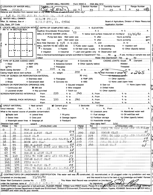
Specific Water Well Detail |
|
|
| Location Info | |||
| Owner: Fuller, Robert | Status: Constructed | ||
| Location: T23S, R32W, Sec. 33, SE NW SE | County: Finney | ||
| Directions: from Jennie Barker Rd, 1.6 mi N, W side | |||
| Latitude: 38.0083608 | Longitude: -100.8345076 | Datum NAD 27 | |
| Latitude: 38.0083834 | Longitude: -100.8349452 | Datum NAD 83 | |
| Longitude and latitude calculated by Survey from township-range-section-quarter calls. Only good to within the quarter call accuracy. | |||
| View well on interactive map | |||
| General Info | ||
| Well Depth: 240 ft. | Elevation: ft. | |
| Static Water Level: 63 ft. | Est. Yield: gpm. | |
| Comp. Date: 16-Nov-1982 | Well Use: Domestic | |
| DWR Applic. #: | Other ID: | |
| Driller Info | ||
| Driller: Paul's Incorporated | License #: 175 | |
| Scanned Form | View scan |
|
Chemical Sample Submitted?: No
Water Well disinfected?: | ||
| Ground water encountered: 0 ft. , 0 ft. , 0 ft. | ||
| Pump test data: Well water was 0 ft after 0 hours pumping 0 gpm | ||
| Casing Info | ||
| Casing Type:
Casing Joints: |
Diam: 0 in. to 0 ft
Diam: 0 in. to 0 ft Diam: 0 in. to 0 ft | |
| Casing height above land surface: in
Casing Weight: lbs/ft Wall thickness or gauge no.: | ||
| Screen and Perforation Info | ||
| Screen Type: | Screen Openings: | |
| Screen-perforated intervals | From: 220 ft to 240 ft
From: 0 ft to 0 ft From: 0 ft to 0 ft | |
| Gravel pack intervals | From: ft to ft | |
| Grout Info | ||
| Grout used: | From: 0 to 0 ft
From: 0 to 0 ft From: 0 to 0 ft | |
| Source of Possible Contamination | ||
| Source: | ||
| Direction from well: | Distance: 0 ft | |
| Lithologic Log
(Log data entered by KGS.) | ||
| From: 0 ft. to 7 ft. | top soil | |
| From: 7 ft. to 21 ft. | brown sandy clay | |
| From: 21 ft. to 30 ft. | gray clay | |
| From: 30 ft. to 38 ft. | fine to medium sand and gravel | |
| From: 38 ft. to 40 ft. | rock and clay | |
| From: 40 ft. to 55 ft. | brown sandy clay | |
| From: 55 ft. to 65 ft. | fine to medium sand and gravel | |
| From: 65 ft. to 67 ft. | hard rock | |
| From: 67 ft. to 76 ft. | brown sandy clay | |
| From: 76 ft. to 110 ft. | fine to medium sand and gravel | |
| From: 110 ft. to 141 ft. | brown sandy clay | |
| From: 141 ft. to 160 ft. | fine sand | |
| From: 160 ft. to 170 ft. | brown sandy clay | |
| From: 170 ft. to 175 ft. | fine to medium sand and gravel | |
| From: 175 ft. to 180 ft. | hard rock | |
| From: 180 ft. to 200 ft. | fine to medium sand and gravel | |
| From: 200 ft. to 212 ft. | brown clay | |
| From: 212 ft. to 225 ft. | fine to medium sand and gravel | |
| From: 225 ft. to 230 ft. | brown sandy clay | |
| From: 230 ft. to 235 ft. | fine to medium sand | |
| From: 235 ft. to 240 ft. | brown clay | |