|
|
|
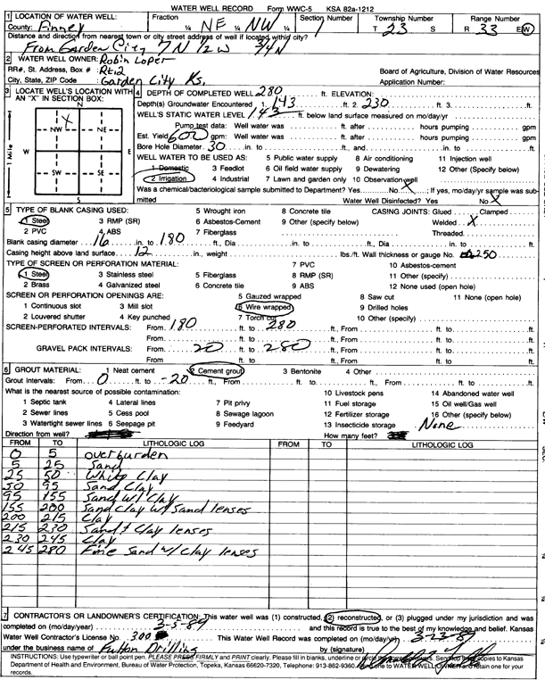
Specific Water Well Detail |
|
|
| Location Info | |||
| Owner: Loper, Robin | Status: Reconstructed | ||
| Location: T23S, R33W, Sec. 1, NE NW | County: Finney | ||
| Directions: from Garden City: 7 mi N, 0.5 mi W, and 0.75 mi N | |||
| Latitude: 38.0893046 | Longitude: -100.8945273 | Datum NAD 27 | |
| Latitude: 38.0893274 | Longitude: -100.8949655 | Datum NAD 83 | |
| Longitude and latitude calculated by Survey from township-range-section-quarter calls. Only good to within the quarter call accuracy. | |||
| View well on interactive map | |||
| General Info | ||
| Well Depth: 280 ft. | Elevation: ft. | |
| Static Water Level: 143 ft. | Est. Yield: 600 gpm. | |
| Comp. Date: 05-Mar-1989 | Well Use: Irrigation | |
| DWR Applic. #: | Other ID: | |
| Links | |
| No Wizard information available. | |
| View info from WIMAS Water Right Data base... | |
| Driller Info | ||
| Driller: Fulton Drilling | License #: 300 | |
| Scanned Form | View scan |
|
Chemical Sample Submitted?: No
Water Well disinfected?: | ||
| Ground water encountered: 143 ft. , 230 ft. , 0 ft. | ||
| Pump test data: Well water was 0 ft after 0 hours pumping 0 gpm | ||
| Casing Info | ||
| Casing Type: Steel
Casing Joints: |
Diam: 16 in. to 180 ft
Diam: 0 in. to 0 ft Diam: 0 in. to 0 ft | |
| Casing height above land surface: in
Casing Weight: lbs/ft Wall thickness or gauge no.: | ||
| Screen and Perforation Info | ||
| Screen Type: Steel | Screen Openings: Wire wrapped | |
| Screen-perforated intervals | From: 180 ft to 280 ft
From: 0 ft to 0 ft From: 0 ft to 0 ft | |
| Gravel pack intervals | From: ft to ft | |
| Grout Info | ||
| Grout used: Cement grout | From: 0 to 20 ft
From: 0 to 0 ft From: 0 to 0 ft | |
| Source of Possible Contamination | ||
| Source: OTHER | ||
| Direction from well: | Distance: 0 ft | |
| Lithologic Log
(Log data entered by KGS.) | ||
| From: 0 ft. to 5 ft. | overburden | |
| From: 5 ft. to 25 ft. | sand | |
| From: 25 ft. to 50 ft. | white clay | |
| From: 50 ft. to 95 ft. | sand and clay | |
| From: 95 ft. to 155 ft. | sand with clay | |
| From: 155 ft. to 200 ft. | sandy clay with sand lenses | |
| From: 200 ft. to 215 ft. | clay | |
| From: 215 ft. to 230 ft. | sand and clay lenses | |
| From: 230 ft. to 245 ft. | clay | |
| From: 245 ft. to 280 ft. | fine sand with clay lenses | |