|
|
|
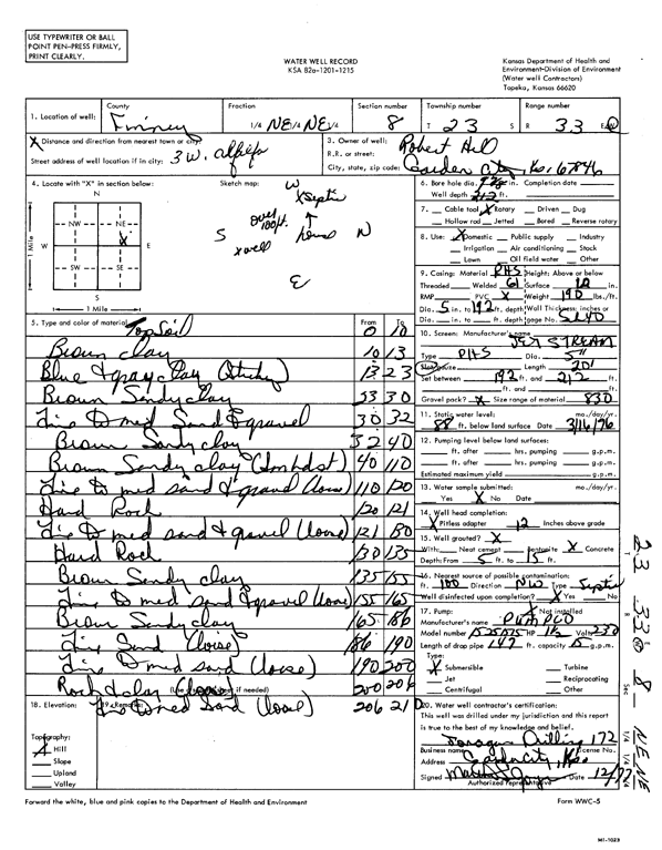
Specific Water Well Detail |
|
|
| Location Info | |||
| Owner: Hill, Robert | Status: Constructed | ||
| Location: T23S, R33W, Sec. 8, NE NE | County: Finney | ||
| Directions: from Alfalfa, 3 mi W | |||
| Latitude: 38.0744485 | Longitude: -100.9586239 | Datum NAD 27 | |
| Latitude: 38.0744721 | Longitude: -100.9590648 | Datum NAD 83 | |
| Longitude and latitude calculated by Survey from township-range-section-quarter calls. Only good to within the quarter call accuracy. | |||
| View well on interactive map | |||
| General Info | ||
| Well Depth: 212 ft. | Elevation: ft. | |
| Static Water Level: 88 ft. | Est. Yield: gpm. | |
| Comp. Date: 01-Dec-1977 | Well Use: Domestic | |
| DWR Applic. #: | Other ID: | |
| Driller Info | ||
| Driller: Jonagan Water Well Service LLC | License #: 172 | |
| Scanned Form | View scan |
|
Chemical Sample Submitted?: No
Water Well disinfected?: | ||
| Ground water encountered: 0 ft. , 0 ft. , 0 ft. | ||
| Pump test data: Well water was 0 ft after 0 hours pumping 0 gpm | ||
| Casing Info | ||
| Casing Type:
Casing Joints: |
Diam: 0 in. to 0 ft
Diam: 0 in. to 0 ft Diam: 0 in. to 0 ft | |
| Casing height above land surface: in
Casing Weight: lbs/ft Wall thickness or gauge no.: | ||
| Screen and Perforation Info | ||
| Screen Type: | Screen Openings: | |
| Screen-perforated intervals | From: 192 ft to 212 ft
From: 0 ft to 0 ft From: 0 ft to 0 ft | |
| Gravel pack intervals | From: ft to ft | |
| Grout Info | ||
| Grout used: | From: 0 to 0 ft
From: 0 to 0 ft From: 0 to 0 ft | |
| Source of Possible Contamination | ||
| Source: | ||
| Direction from well: | Distance: 0 ft | |
| Lithologic Log
(Log data entered by KGS.) | ||
| From: 0 ft. to 10 ft. | topsoil | |
| From: 10 ft. to 13 ft. | brown clay | |
| From: 13 ft. to 23 ft. | blue and gray clay (sticky) | |
| From: 23 ft. to 30 ft. | brown sandy clay | |
| From: 30 ft. to 32 ft. | fine to medium sand and gravel | |
| From: 32 ft. to 40 ft. | brown sandy clay | |
| From: 40 ft. to 110 ft. | brown sandy clay (sm hd st) | |
| From: 110 ft. to 120 ft. | fine to medium sand and gravel (loose) | |
| From: 120 ft. to 121 ft. | hard rock | |
| From: 121 ft. to 130 ft. | fine to medium sand and gravel (loose) | |
| From: 130 ft. to 135 ft. | hard rock | |
| From: 135 ft. to 155 ft. | brown sandy clay | |
| From: 155 ft. to 165 ft. | fine to medium sand and gravel (loose) | |
| From: 165 ft. to 186 ft. | brown sandy clay | |
| From: 186 ft. to 190 ft. | fine sand (loose) | |
| From: 190 ft. to 200 ft. | fine to medium sand (loose) | |
| From: 200 ft. to 206 ft. | rock and clay (loose) | |
| From: 206 ft. to 210 ft. | fine to medium sand (loose) | |