|
|
|
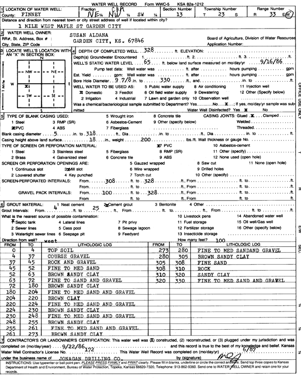
Specific Water Well Detail |
|
|
| Location Info | |||
| Owner: Aldana, Susan | Status: Constructed | ||
| Location: T23S, R33W, Sec. 13, NE NW SW | County: Finney | ||
| Directions: 1 mi W Maple St, Garden City | |||
| Latitude: 38.0539381 | Longitude: -100.8977777 | Datum NAD 27 | |
| Latitude: 38.0539611 | Longitude: -100.8982169 | Datum NAD 83 | |
| Longitude and latitude calculated by Survey from township-range-section-quarter calls. Only good to within the quarter call accuracy. | |||
| View well on interactive map | |||
| General Info | ||
| Well Depth: 328 ft. | Elevation: ft. | |
| Static Water Level: 65 ft. | Est. Yield: gpm. | |
| Comp. Date: 22-Sep-1986 | Well Use: Domestic | |
| DWR Applic. #: | Other ID: | |
| Driller Info | ||
| Driller: Jonagan Drilling Co. | License #: 172 | |
| Scanned Form | View scan |
|
Chemical Sample Submitted?: No
Water Well disinfected?: | ||
| Ground water encountered: 0 ft. , 0 ft. , 0 ft. | ||
| Pump test data: Well water was 0 ft after 0 hours pumping 0 gpm | ||
| Casing Info | ||
| Casing Type: PVC
Casing Joints: |
Diam: 5 in. to 318 ft
Diam: 0 in. to 0 ft Diam: 0 in. to 0 ft | |
| Casing height above land surface: in
Casing Weight: lbs/ft Wall thickness or gauge no.: | ||
| Screen and Perforation Info | ||
| Screen Type: | Screen Openings: Mill slot | |
| Screen-perforated intervals | From: 0 ft to 328 ft
From: 0 ft to 0 ft From: 0 ft to 0 ft | |
| Gravel pack intervals | From: ft to ft | |
| Grout Info | ||
| Grout used: Cement grout | From: 4 to 25 ft
From: 0 to 0 ft From: 0 to 0 ft | |
| Source of Possible Contamination | ||
| Source: Septic Tank | ||
| Direction from well: | Distance: 0 ft | |
| Lithologic Log
(Log data entered by KGS.) | ||
| From: 0 ft. to 4 ft. | top soil | |
| From: 4 ft. to 37 ft. | coarse gravel | |
| From: 37 ft. to 45 ft. | rock and gravel | |
| From: 45 ft. to 52 ft. | fine to medium sand | |
| From: 52 ft. to 63 ft. | brown sandy clay | |
| From: 63 ft. to 72 ft. | fine to sand and gravel | |
| From: 72 ft. to 180 ft. | brown sandy clay | |
| From: 180 ft. to 204 ft. | fine to medium sand and gravel | |
| From: 204 ft. to 220 ft. | brown clay | |
| From: 220 ft. to 224 ft. | fine to medium sand and gravel | |
| From: 224 ft. to 230 ft. | brown sandy clay | |
| From: 230 ft. to 248 ft. | fine to medium sand and gravel | |
| From: 248 ft. to 255 ft. | brown sandy clay | |
| From: 255 ft. to 261 ft. | fine to medium sand and gravel | |
| From: 261 ft. to 273 ft. | brown sandy clay | |
| From: 273 ft. to 280 ft. | fine to medium sand and gravel | |
| From: 280 ft. to 305 ft. | brown sandy clay | |
| From: 305 ft. to 308 ft. | fine sand | |
| From: 308 ft. to 310 ft. | rock | |
| From: 310 ft. to 320 ft. | sandy clay | |
| From: 320 ft. to 330 ft. | fine to medium sand and gravel | |