|
|
|
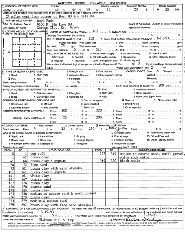
Specific Water Well Detail |
|
|
| Location Info | |||
| Owner: Funk, Boyd | Status: Constructed | ||
| Location: T23S, R33W, Sec. 15, NE NW NE | County: Finney | ||
| Directions: from Hwy 83 and 6 Mile Rd, 2.5 mi W | |||
| Latitude: 38.0611261 | Longitude: -100.9255544 | Datum NAD 27 | |
| Latitude: 38.0611494 | Longitude: -100.9259944 | Datum NAD 83 | |
| Longitude and latitude calculated by Survey from township-range-section-quarter calls. Only good to within the quarter call accuracy. | |||
| View well on interactive map | |||
| General Info | ||
| Well Depth: 320 ft. | Elevation: ft. | |
| Static Water Level: 113 ft. | Est. Yield: 75 gpm. | |
| Comp. Date: 19-Mar-1993 | Well Use: Domestic | |
| DWR Applic. #: | Other ID: | |
| Driller Info | ||
| Driller: Midwest Well & Pump, Inc. | License #: 532 | |
| Scanned Form | View scan |
|
Chemical Sample Submitted?: No
Water Well disinfected?: | ||
| Ground water encountered: 0 ft. , 0 ft. , 0 ft. | ||
| Pump test data: Well water was 0 ft after 0 hours pumping 0 gpm | ||
| Casing Info | ||
| Casing Type: PVC
Casing Joints: |
Diam: 5 in. to 0 ft
Diam: 0 in. to 0 ft Diam: 0 in. to 0 ft | |
| Casing height above land surface: in
Casing Weight: lbs/ft Wall thickness or gauge no.: | ||
| Screen and Perforation Info | ||
| Screen Type: PVC | Screen Openings: Saw cut | |
| Screen-perforated intervals | From: 300 ft to 320 ft
From: 0 ft to 0 ft From: 0 ft to 0 ft | |
| Gravel pack intervals | From: ft to ft | |
| Grout Info | ||
| Grout used: Bentonite | From: 5 to 25 ft
From: 290 to 320 ft From: 0 to 0 ft | |
| Source of Possible Contamination | ||
| Source: Septic Tank | ||
| Direction from well: | Distance: 0 ft | |
| Lithologic Log
(Log data entered by KGS.) | ||
| From: 0 ft. to 1 ft. | top soil | |
| From: 1 ft. to 41 ft. | brown clay | |
| From: 41 ft. to 64 ft. | brown clay and gypsum | |
| From: 64 ft. to 72 ft. | fine sand | |
| From: 72 ft. to 101 ft. | brown clay with sand streaks | |
| From: 101 ft. to 141 ft. | brown clay and gypsum | |
| From: 141 ft. to 161 ft. | white clay | |
| From: 161 ft. to 167 ft. | coarse sand | |
| From: 167 ft. to 174 ft. | brown clay | |
| From: 174 ft. to 178 ft. | coarse sand | |
| From: 178 ft. to 185 ft. | brown clay | |
| From: 185 ft. to 236 ft. | medium to coarse sand and small gravel | |
| From: 236 ft. to 273 ft. | brown clay | |
| From: 273 ft. to 279 ft. | medium and coarse sand | |
| From: 279 ft. to 297 ft. | brown clay with fine sand streaks | |
| From: 297 ft. to 319 ft. | medium to coarse sand, small gravel white rock chips | |
| From: 319 ft. to 320 ft. | black shale | |