|
|
|
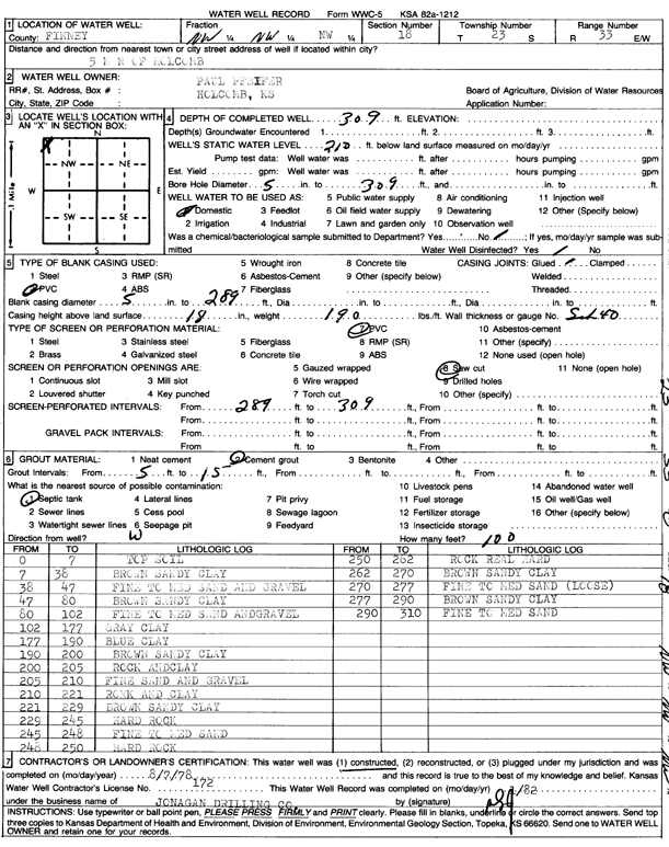
Specific Water Well Detail |
|
|
| Location Info | |||
| Owner: Pfeifer, Paul | Status: Constructed | ||
| Location: T23S, R33W, Sec. 18, NW NW NW | County: Finney | ||
| Directions: from Holcomb, 5 mi N | |||
| Latitude: 38.0608016 | Longitude: -100.9914625 | Datum NAD 27 | |
| Latitude: 38.0608255 | Longitude: -100.991905 | Datum NAD 83 | |
| Longitude and latitude calculated by Survey from township-range-section-quarter calls. Only good to within the quarter call accuracy. | |||
| View well on interactive map | |||
| General Info | ||
| Well Depth: 309 ft. | Elevation: ft. | |
| Static Water Level: 210 ft. | Est. Yield: gpm. | |
| Comp. Date: 07-Aug-1978 | Well Use: Domestic | |
| DWR Applic. #: | Other ID: | |
| Links | |
| View info from Wizard Water Level Data base... | |
| No WIMAS information available. | |
| Driller Info | ||
| Driller: Jonagan Drilling Co. | License #: 172 | |
| Scanned Form | View scan |
|
Chemical Sample Submitted?: No
Water Well disinfected?: | ||
| Ground water encountered: 0 ft. , 0 ft. , 0 ft. | ||
| Pump test data: Well water was 0 ft after 0 hours pumping 0 gpm | ||
| Casing Info | ||
| Casing Type:
Casing Joints: |
Diam: 0 in. to 0 ft
Diam: 0 in. to 0 ft Diam: 0 in. to 0 ft | |
| Casing height above land surface: in
Casing Weight: lbs/ft Wall thickness or gauge no.: | ||
| Screen and Perforation Info | ||
| Screen Type: | Screen Openings: | |
| Screen-perforated intervals | From: 289 ft to 309 ft
From: 0 ft to 0 ft From: 0 ft to 0 ft | |
| Gravel pack intervals | From: ft to ft | |
| Grout Info | ||
| Grout used: | From: 0 to 0 ft
From: 0 to 0 ft From: 0 to 0 ft | |
| Source of Possible Contamination | ||
| Source: | ||
| Direction from well: | Distance: 0 ft | |
| Lithologic Log
(Log data entered by KGS.) | ||
| From: 0 ft. to 7 ft. | top soil | |
| From: 7 ft. to 38 ft. | brown sandy clay | |
| From: 38 ft. to 47 ft. | fine to medium sand and gravel | |
| From: 47 ft. to 80 ft. | brown sandy clay | |
| From: 80 ft. to 102 ft. | fine to medium sand and gravel | |
| From: 102 ft. to 177 ft. | gray clay | |
| From: 177 ft. to 190 ft. | blue clay | |
| From: 190 ft. to 200 ft. | brown sandy clay | |
| From: 200 ft. to 205 ft. | rock and clay | |
| From: 205 ft. to 210 ft. | fine sand and gravel | |
| From: 210 ft. to 221 ft. | rock and clay | |
| From: 221 ft. to 229 ft. | brown sandy clay | |
| From: 229 ft. to 245 ft. | hard rock | |
| From: 245 ft. to 248 ft. | fine to medium sand | |
| From: 248 ft. to 250 ft. | hard rock | |
| From: 250 ft. to 262 ft. | rock real hard | |
| From: 262 ft. to 270 ft. | brown sandy clay | |
| From: 270 ft. to 277 ft. | fine to medium sand (loose) | |
| From: 277 ft. to 290 ft. | brown sandy clay | |
| From: 290 ft. to 310 ft. | fine to medium sand | |