|
|
|
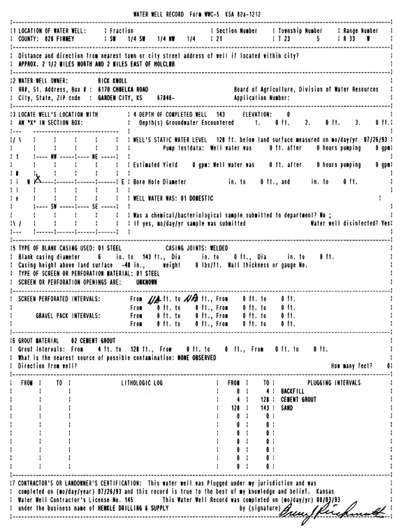
Specific Water Well Detail |
|
|
| Location Info | |||
| Owner: Knoll, Rick | Status: Plugged | ||
| Location: T23S, R33W, Sec. 21, SW SW NW | County: Finney | ||
| Directions: from Holcomb 2.5 mi N and 2 mi E | |||
| Latitude: 38.040829 | Longitude: -100.9553167 | Datum NAD 27 | |
| Latitude: 38.0408527 | Longitude: -100.9557583 | Datum NAD 83 | |
| Longitude and latitude calculated by Survey from township-range-section-quarter calls. Only good to within the quarter call accuracy. | |||
| View well on interactive map | |||
| General Info | ||
| Well Depth: 143 ft. | Elevation: ft. | |
| Static Water Level: 128 ft. | Est. Yield: gpm. | |
| Comp. Date: 26-Jul-1993 | Well Use: Domestic | |
| DWR Applic. #: | Other ID: | |
| Driller Info | ||
| Driller: Hydro Resources Mid Continent, Inc. | License #: 145 | |
| Scanned Form | View scan |
| Casing Info | ||
|
Casing Type: Steel
Diam: 6 in. Casing height above land surface: in | ||
| Grout Info | ||
| Grout used: Cement grout | From: 4 to 128 ft
From: 0 to 0 ft From: 0 to 0 ft | |
| Source of Possible Contamination | ||
| Source: OTHER | ||
| Direction from well: | Distance: 0 ft | |