|
|
|
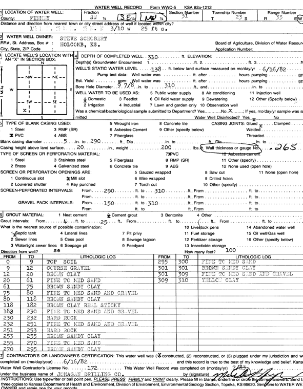
Specific Water Well Detail |
|
|
| Location Info | |||
| Owner: Schobert, Steve | Status: Constructed | ||
| Location: T23S, R33W, Sec. 31, SW SE NW | County: Finney | ||
| Directions: from Holcomb, 1.5 mi N, 0.5 mi E, 0.5 mi N, 0.3 mi W, and 25 feet S | |||
| Latitude: 38.0117443 | Longitude: -100.9872491 | Datum NAD 27 | |
| Latitude: 38.0117685 | Longitude: -100.9876927 | Datum NAD 83 | |
| Longitude and latitude calculated by Survey from township-range-section-quarter calls. Only good to within the quarter call accuracy. | |||
| View well on interactive map | |||
| General Info | ||
| Well Depth: 310 ft. | Elevation: ft. | |
| Static Water Level: 138 ft. | Est. Yield: gpm. | |
| Comp. Date: 16-Jun-1982 | Well Use: Domestic | |
| DWR Applic. #: | Other ID: | |
| Driller Info | ||
| Driller: Jonagan Water Well Service LLC | License #: 172 | |
| Scanned Form | View scan |
|
Chemical Sample Submitted?: No
Water Well disinfected?: | ||
| Ground water encountered: 0 ft. , 0 ft. , 0 ft. | ||
| Pump test data: Well water was 0 ft after 0 hours pumping 0 gpm | ||
| Casing Info | ||
| Casing Type:
Casing Joints: |
Diam: 0 in. to 0 ft
Diam: 0 in. to 0 ft Diam: 0 in. to 0 ft | |
| Casing height above land surface: in
Casing Weight: lbs/ft Wall thickness or gauge no.: | ||
| Screen and Perforation Info | ||
| Screen Type: | Screen Openings: | |
| Screen-perforated intervals | From: 290 ft to 310 ft
From: 0 ft to 0 ft From: 0 ft to 0 ft | |
| Gravel pack intervals | From: ft to ft | |
| Grout Info | ||
| Grout used: | From: 0 to 0 ft
From: 0 to 0 ft From: 0 to 0 ft | |
| Source of Possible Contamination | ||
| Source: | ||
| Direction from well: | Distance: 0 ft | |
| Lithologic Log
(Log data entered by KGS.) | ||
| From: 0 ft. to 9 ft. | top soil | |
| From: 9 ft. to 12 ft. | coarse gravel | |
| From: 12 ft. to 20 ft. | brown clay | |
| From: 20 ft. to 61 ft. | fine to medium sand | |
| From: 61 ft. to 75 ft. | brown sandy clay | |
| From: 75 ft. to 80 ft. | fine to medium sand and gravel | |
| From: 80 ft. to 118 ft. | brown sandy clay | |
| From: 118 ft. to 182 ft. | brown clay real sticky | |
| From: 182 ft. to 230 ft. | fine to medium sand and gravel | |
| From: 230 ft. to 232 ft. | hard rock | |
| From: 232 ft. to 251 ft. | fine to medium sand and gravel | |
| From: 251 ft. to 253 ft. | hard rock | |
| From: 253 ft. to 255 ft. | brown sandy clay | |
| From: 255 ft. to 270 ft. | fine to medium sand | |
| From: 270 ft. to 295 ft. | brown sandy clay | |
| From: 295 ft. to 300 ft. | fine to medium sand | |
| From: 300 ft. to 301 ft. | brown sandy clay | |
| From: 301 ft. to 309 ft. | fine to medium sand and gravel | |
| From: 309 ft. to 310 ft. | yellow clay | |